Jordan | The date of the start of the depression’s effects on the Kingdom is approaching, and serious warnings of the danger of torrential rains, especially in the southern regions
Arab Weather - With the hours of Sunday evening, it is expected that an air depression classified in the third degree (medium to high impact) will gradually approach the Kingdom, according to the Arab weather scale for the intensity of the depressions, which begins its effects with the dawn and morning hours of Monday.
In the details, the weather tonight will be cold with the appearance of quantities of low clouds and during the late night hours the clouds will multiply so that the weather is completely cloudy, and the opportunity is gradually created for precipitation during the hours after midnight and dawn starting from the southern regions, and the rain gradually extends with the hours of dawn and early morning to In the rest of the regions, the winds will be southwesterly, moderate in speed.
The Kingdom is affected by a third-degree depression (medium to highly effective) that brings cold winter weather and heavy rain to various regions, especially the southern regions of the Kingdom.
On Monday, it is expected that temperatures will drop to be lower than their usual rates for this time of the year between 2-4 degrees Celsius, and the weather will be cold, cloudy and rainy at times in most of the northern, central and southern regions (including Aqaba) and parts of The eastern regions, and the rains are heavy at intervals and may be accompanied by lightning and thunder, and are accompanied by hail, especially over the southern mountain highlands, with an alert of the formation of torrents, as it is expected that fog will form and the clouds touching the surface of the earth will cross over the mountain highlands, and cold to very cold weather prevails, especially over the peaks High mountains, especially in the south of the Kingdom.
It is not excluded that hail showers are sometimes heavy over the mountainous heights, especially the southern ones.
And with Monday evening hours; The weather is cold to very cold in various regions, and rain continues at intervals in different parts of the Kingdom, especially the southern regions, where it is sometimes heavy.
There is also an opportunity for showers of snow to fall over the peaks of the southern highlands, which are more than 1,600 meters above sea level, and include the peaks of the Tafila heights such as Al-Rashadiya, and the peaks of the Sharah heights such as Al-Hishah in the upper Al-Shobak. .
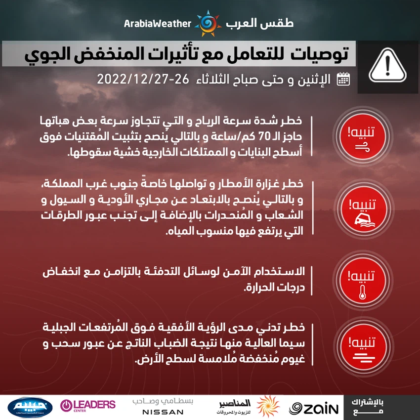
Important recommendations and alerts to deal with the upcoming depression:
- Warning of the formation of torrents and the flow of valleys due to the heavy rain sometimes in various regions, especially in the southern regions and highlands.
- Be aware of the low horizontal visibility due to the fog over the mountain heights.
- Driving with caution on the roads in the high mountainous areas, especially the south, due to the hail, which may be heavy at times.
- Be aware of the low horizontal visibility due to the fog over the mountain heights
Browse on the official website