Hurricane Beryl is developing into the maximum and most dangerous category `Five` and threatens the Caribbean Islands, Guatelama and Mexico with its torrential rains and strong winds.
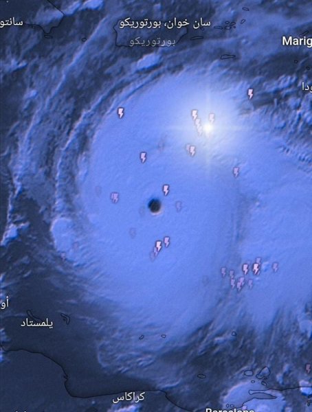
Arabia Weather - The weather specialists at the Air Control Center in Arabia Weather are monitoring the latest indications of the internally developed remote sensing systems, in addition to what the monitoring systems monitor about the tropical cyclone (Beryl), which has developed today to the maximum degree, which is the fifth degree, with the emergence of the eye of the hurricane, which Very large amounts of cumulonimbus clouds are wrapped around it, carrying large amounts of rain and severe thunderstorms, which are now accompanied by strong winds over the waters of the western Atlantic Ocean.
According to the latest observations received from the Air Traffic Control Center regarding Hurricane Beryl:
- The maximum wind speed around the eye wall of the hurricane is now: 266 km/h, which is strong winds with a record speed.
- The lowest observed value of atmospheric pressure at the center of the eye of the hurricane is 935 millibars, which is a very low value.
- The maximum wave height observed: 15 meters, which is the height of a multi-storey residential building
- The latitude at which the huge hurricane is centered: 15 north
- Weather Monitoring Center: Forecasts indicate that the hurricane will move west, but its category is expected to decline, with the danger level remaining high.
After monitoring the latest computer modeling data at the Arabia Weather Center, it is expected that the hurricane will continue to move westward into the waters of the Caribbean Sea to hit the Caribbean islands strongly before retreating on Thursday and Friday when it reaches Mexico and Guatelama, but it also threatens with floods and landslides. The path and intensity forecasts can be stated in the following points according to For the latest updates, which can be updated according to developments that may occur in the hurricane:
Tuesday : The huge hurricane continues within the fifth category and moves westward, affecting various Caribbean islands with its strong winds, torrential rains, and rough waves.
Wednesday : The hurricane continues to move westward into the waters of the Caribbean Sea, but its classification has dropped to become a third category according to international standards, which is an advanced category and of high danger. Its rains, winds, and waves will hit the Dominican Republic and Haiti, threatening floods and submerging coastal areas with waves.
Thursday : According to preliminary data, the hurricane’s classification will be reduced to within the category 2 category, but this time the eye wall will cross the island of Jamaica, unlike the rest of the islands that the hurricane was passing alongside, and thus the entire island will be within a very high level of danger in terms of heavy rain, winds, and strong waves.
Friday : The hurricane initially weakens to the first category when it reaches southern Mexico and passes along Nicaragua and Guatelama, accompanied by strong winds and heavy rains, and also threatens the dangers of torrents and floods to those areas.
Saturday : The hurricane crosses the land and reaches the Gulf of Mexico, but it is classified as a tropical storm at the time. However, the possibility of the tropical system developing to higher degrees due to the warmth of the surface waters of the Gulf of Mexico is being monitored in Arabia Weather.
God knows
Browse on the official website