Saudi Arabia | Intense rains in the southwest of the Kingdom, and active winds and dust raised in parts of the Eastern Province during the weekend
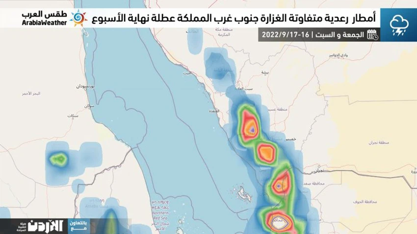
Weather of Arabia - Atmospheric maps extracted from computer simulation models show expectations of an increase in the flow of tropical moisture to the atmosphere of the southwestern highlands from the Kingdom during this weekend, and this will result in the intensification of cumulus clouds on the southwestern highlands, God willing.
In the details, it is expected that convective clouds will be active on Friday and Saturday on the hills of Tehama, Jazan, Asir and parts of the heights of Al Baha and south of Makkah Al-Mukarramah, to rain showers of varying intensity, be heavy in some neighborhoods and associated with hail and sometimes thunderstorms. Which may cause the flow of valleys and reefs in some areas and may form torrential rain, especially on Saturday.
Relatively hot weather prevails in the northern regions during daylight hours, while it remains very hot in the rest of the Kingdom’s regions, except for the highlands. The winds are northwesterly active, with speed on the eastern region, which may raise some dust and dust, God willing. As for at night, the atmosphere is hot in most regions and Humid coastal areas.
Recommendations:
- It is advised to pay attention to the dangers of sudden floods in parts of the southwest of the Kingdom when thunder rain falls, especially in areas of slopes, where it is advised to stay away from valleys, reefs and torrential streams, especially on Saturday.
- Attention to the high proportion of dust in the atmosphere in parts of the eastern region.
God knows.
Browse on the official website