Saudi Arabia | The Kingdom receives the first Khamasini depression for this season, and dust is its most prominent feature

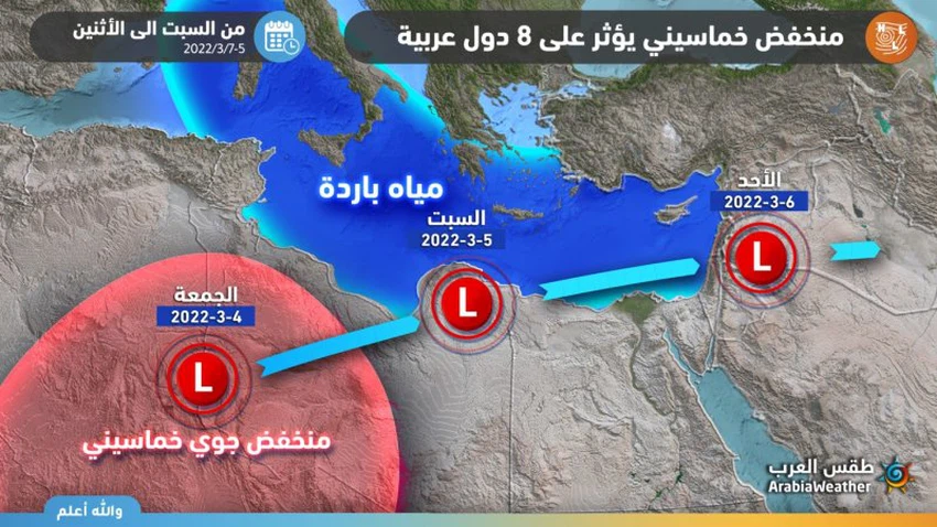
Weather of Arabia - The outputs of computer simulations of weather systems and wind forecasts indicate that many Arab countries, including Saudi Arabia, are affected by a Khamasini air depression that begins its journey from the Sahara Desert, and takes a path inland from Libyan territory to the eastern basin of the Mediterranean, the Levant region and North Saudi Arabia, and this Khamasini depression is considered early for this time of the year, and is expected to bring more dust to Saudi lands.

Khamasini depression accompanied by dust
Areas covered by dust forecast for Sunday and Monday
In the details, it is expected that the Khamasini depression will be centered on Sunday to the north of Egypt, which will push strong westerly winds towards the northern parts of the Kingdom, including Tabuk, Al-Jawf and the northern border region, and it is expected that these winds will stir up dust and dust with varying intensity.
As for Monday, the Khamasini air depression moves westward to center over Iraqi lands, and the wind speed decreases in all regions except for the northern borders and Hafr Al-Batin, and parts of the center and east of the Kingdom, so that it works to raise dust and dust with varying severity, and God knows best.
Why are the pentagonal depressions formed at this time of the year?
The Khamsiniyah depressions are known as thermal depressions that usually form in the spring in the northern part of the continent of Africa (in the Sahara), and move parallel to the coast of the Mediterranean towards the eastern basin of the Mediterranean and the Levant region. Thermal depression is defined as a depression resulting from the intense heating of the Earth’s surface, which results in a decrease in the density of the air above it, so it rises up and the pressure decreases, and the air begins to gather from areas of high pressure towards areas of low pressure, and an upward movement is formed that is in a narrow vertical space.
The five-year depressions are formed in the Sahara and North Africa in this period of the year (the spring period) as a result of the decrease in atmospheric pressure due to the high temperature there compared to the temperature of the Mediterranean water, which becomes cold after the winter season. These depressions push the surface winds laden with dust from the Sahara desert towards the east.
The Khamasin depressions are usually accompanied by the Khamasin winds, which are mostly southwesterly winds, which are dry and warm and come from the Sahara Desert, loaded with tons of dust and raised dust, and move quickly towards areas of the eastern Mediterranean, such as Egypt, the Levant, Iraq, and the Arabian Peninsula region. Temperatures and dusty conditions will reduce visibility.
Browse on the official website
