Atlantic Ocean | Weeks after Hurricane Beryl ended, the National Hurricane Center warns of a possible development of tropical activity next week (details)
Arabia Weather - After the end of Hurricane Beryl, the last tropical storm that formed in the Atlantic Ocean, and after several weeks have passed since the air disturbances subsided in the region favored for the formation of tropical storms and hurricanes, indications are increasing of the return of tropical strikes in the Atlantic Ocean in the coming days.
In detail: Monitoring devices specialized in monitoring tropical and tropical conditions in the Atlantic Ocean have indicated the development of an air disturbance east of the Lesser Antilles, where, according to recent observations, it is expected to interact with a tropical wave approaching the region during the next few days.
The National Hurricane Center said in its latest forecasts that environmental conditions in the waters of the Atlantic Ocean are favorable for the developments of tropical activity within the coming days, especially during the weekend and next week, and forecasts indicate the possibility of the disturbance developing into a tropical depression by the middle of next week in the region near the Leeward Islands. North, Greater Antilles, or southwest Atlantic, where the system is then expected to head toward Florida or the southeast coast.
Arabian weather specialists: The water temperature of the Atlantic Ocean is high and a fertile environment for the development of hurricanes
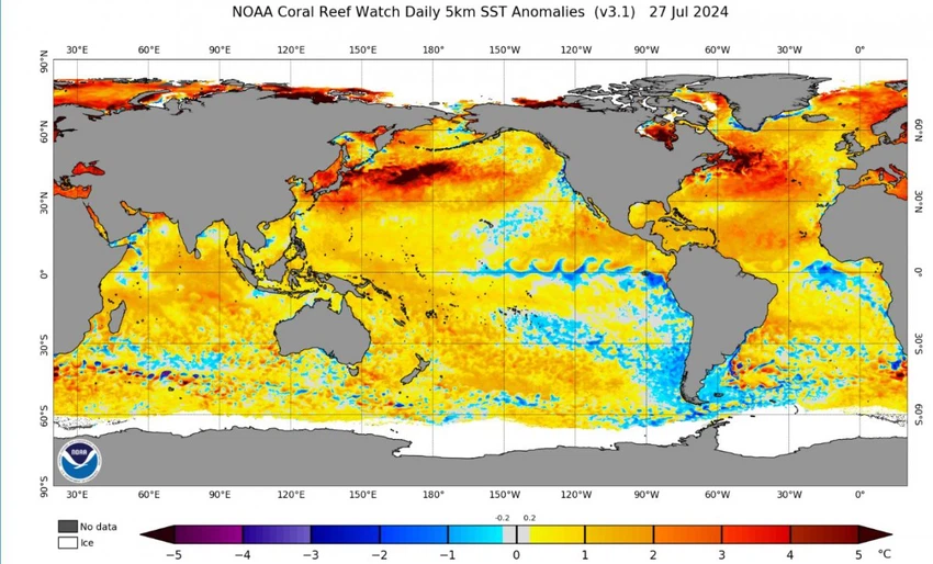
The specialists at the Arab Weather Center said that the latest updates on the temperature of water bodies indicate a significant increase in the temperature of the region that is favorable for the formation of hurricanes in the Atlantic Ocean, which increases the evaporation process, as the rise in temperature of the ocean surface is considered the main nutrient and serves as fuel for the formation of hurricanes. Tropical, and the following map from NOAA shows the significant rise above the general averages, which exceeds 3 degrees in the region favoring the formation of tropical conditions:

Read also:
The meteorological specialists in “Arab Weather” reported that the speed of surface winds has an important role in raising the temperature of the sea surface, as the decrease in wind speeds leads to a decrease in the mixing of surface water with the cold water at the bottom of the sea, which allows its temperatures to rise significantly, and the decrease in the speed of Surface winds weaken the rise of cooler deep water along the Canary Islands Current, “an ocean current that flows south along the coast of West Africa and then west into the North Atlantic near the Cape Verde Islands.”
Another consequence of the decrease in surface wind speed is the weak movement of desert dust over the Atlantic Ocean, which helps in the rapid increase in sea surface temperatures, as usually the increase in the proportion of dust helps scatter solar radiation back into space before it reaches the surface of the ocean.
The National Hurricane Center said that if the system develops into a tropical storm, it will be named “ Debbie ,” which is the fourth named storm for the 2024 Atlantic hurricane season, as it is still uncertain how the system will develop and where it will head after reaching the Lesser Antilles. The National Hurricane Center said Fox Forecast Any interaction with mountains in the Caribbean islands will play a major role in the system's evolution.
Browse on the official website