After warmer than usual temperatures, a radical reversal is expected in the atmosphere, and a series of polar masses is approaching the region
Arab weather - despite the stability of the atmosphere in the rest of the Levant and Egypt these days, where temperatures ranged above their usual rates by many degrees and for several days, the Department of Operations and Weather Forecasts in Arab Weather is closely monitoring the outputs of the weather maps, which now indicate that there is a change A drastic forecast for the weather from the end of this week.
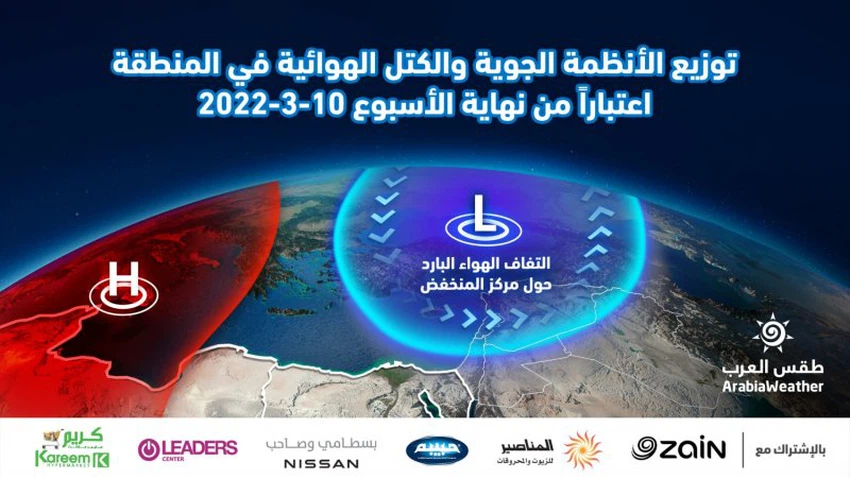
In the details, the latest weather readings indicate that there is an air rise in various layers of the air that will control large parts of the European continent and expand north to the Scandinavian Peninsula, and simultaneously with that, a polar and very cold air mass is pushed by the same air rise to fall to the east and southeast Europe and the Balkan Basin, and with the occurrence of a constant distribution of air masses and air systems from the Atlantic Ocean, the Arctic and the European continent, this will be a major factor that ensures the continued influx of very cold air masses towards the region.
The same weather maps issued by the Arab Weather Center indicate that the rest of the countries of the eastern basin of the Mediterranean are on a date with air activity, which is affected by a series of very strong air masses, as of Thursday, March 10, accompanied by a significant drop in temperatures and a complete reversal of the atmosphere. , so that the temperatures fall dramatically compared to what they were in the past days, and the occurrence of large-scale frost and ice waves in all regions of the Levant, Egypt, Iraq and even northern Saudi Arabia.
As for snow, the arrival of these polar air masses in that region requires more complex air systems to cause snowfall, and according to those air map updates issued on Monday morning 07-03-2022, it is not expected that the polar masses of the eastern Mediterranean countries will rush in sufficiently and allow Due to the low temperature and the transformation of rain into snow in large areas, the chances of snow are the best possible over high altitudes.
This is due to the deepening of a winter storm in northeastern Europe, which leads to the detention of the bulk of the cold polar air there, that is, southeast of the European continent, specifically over Turkish lands, which is expected to receive a snow storm that paralyzes most of the facilities of life in those areas.
Browse on the official website