The Levant | A moderate air mass that casts a shadow over the country, starting from Saturday, accompanied by unstable weather conditions in many regions.
Arab Weather - The latest weather updates indicate indications of a moderate air mass eruption towards the eastern Mediterranean and the Levant region on Saturday, as temperatures drop to become less than their annual rates for such a time of the year, and temperatures also decrease at night to become cold in most of Regions.
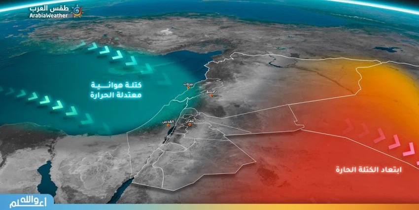
Significant decrease in temperature coinciding with unstable weather conditions
The temperatures begin to gradually decrease with Friday in Palestine and Jordan, but temperatures continue to be the same in Syria and Lebanon, but from Saturday the rest of the Levant is affected by a moderate air mass, so that it is around the beginning of twenty degrees Celsius in large parts of the Levant.
The Kingdom is affected by unstable weather conditions, starting from Friday, accompanied by an opportunity for showers of rain in parts of eastern Jordan, the coasts of Palestine and Lebanon, and large parts of Syria. Interior of the Levant.
The reason for the moderate air mass rush to the Levant
A very cold air mass pushes towards the British Isles this weekend, pushing the African hot air mass north towards the western Mediterranean and southern European continent, in return, and in response to this hot dash towards the west of the European continent, a cold air mass rushes towards the east of the European continent and Turkey this time and then Later, towards the eastern Mediterranean and the Levant.
Weather conditions and expected temperatures in the capitals of the Levant on Friday and Saturday:
- Scattered clouds with light dust
- The expected maximum temperature in Al-Quds Al-Sharif Friday: 26 °
- The expected minimum temperature in Al-Quds Al-Sharif Friday: 18 °
- Light dust some back
- The expected maximum temperature in Al-Quds Al-Sharif Saturday: 21 °
- The expected minimum temperature in Al-Quds Al-Sharif Saturday: 16 °
- Scattered clouds
- The expected maximum temperature in Amman, Friday: 29 °
- The expected minimum temperature in Amman, Friday: 16 °
- Scattered clouds with light dust
- The expected maximum temperature in Amman, Saturday: 24 °
- The expected minimum temperature in Amman on Saturday: 14 °
- Scattered clouds with the possibility of light rain
- The expected maximum temperature in Damascus, Friday: 38 °
- The expected minimum temperature in Damascus, Friday: 16 °
- Clear
- The expected maximum temperature in Damascus Saturday: 30 °
- The expected minimum temperature in Damascus on Saturday: 10 °
- partially cloudy
- The expected maximum temperature in Beirut Friday: 26 °
- The expected minimum temperature in Beirut on Friday: 18 °
- Partly cloudy with a chance of light rain
- The expected maximum temperature in Beirut on Saturday: 23 °
- The expected minimum temperature in Beirut on Saturday: 17 °
Browse on the official website