Sultanate of Oman | Areas covered by rain forecast on Wednesday 6-7-2022

Written By محمد عوينة on 2022/07/06

This article was written originally in Arabic and is translated using a 3rd party automated service. ArabiaWeather is not responsible for any grammatical errors whatsoever.

Arab Weather - The latest weather maps indicate expectations that the Sultanate will continue to be affected on Wednesday by a low air extension coming from the Indian subcontinent, which leads to the continuation of unstable weather conditions in many parts of the Sultanate, God willing.


Rain of varying intensity, accompanied by active winds

Areas covered by rain forecast in the Sultanate on Wednesday

In the details, it is expected that the activity of local formations will continue on the Hajar mountain range on Wednesday, specifically in the mountainous areas located in the governorates of Al Buraimi, Al Dakhiliyah, Al Dhahirah and North Al Sharqiyah, accompanied by rainfall of varying intensity, sometimes thunderous, accompanied by active downward winds, and extending with the afternoon and evening hours of the desert areas. This coincides with the continued flow of cumulus clouds to some northern governorates of the Sultanate.


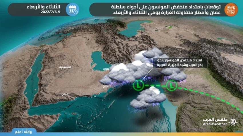
With the late night hours, and as a result of the approaching depression of the atmosphere of the Sultanate, quantities of convective rainy clouds flow over parts of the coasts of the Sea of Oman, to gradually extend to include large parts of the northern governorates.


God knows

This article was written originally in Arabic and is translated using a 3rd party automated service. ArabiaWeather is not responsible for any grammatical errors whatsoever.


Browse on the official website


Monitoring the consequences of a polar vortex splitA cold wave is affecting several Gulf countries, causing a noticeable drop in temperature starting at the end of the week.O God, have mercy on a thousand tents.. Extremely cold weather tonight in Gaza with intermittent rainCold polar winds affect Gaza, dropping night temperatures to less than 5 degrees Celsius in some areasA strong high pressure system is controlling western Europe and causing a huge polar air mass to rush towards eastern Europe.A low pressure system will affect Gaza starting tonight, followed by a very cold air mass starting Saturday, February 22, 2025.Low pressure and heavy rain in Gaza, followed by cold polar winds and worsening humanitarian conditionsMajor consequences of polar vortex split, resulting in a cold wave that brings temperatures to -50 degrees Celsius in the United StatesSaad Balaa (Iblaa) in the collective heritage of the Arab East