Important | The rainy situation is renewed strongly on Saturday, alerting the abundance of rain and intense cold in many regions
Update | Saturday 4/17/2021 at 9:30 a.m.
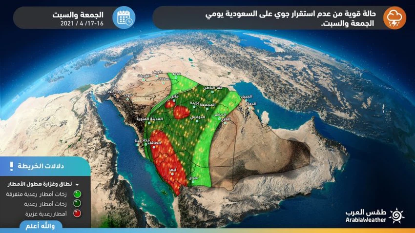
Arab Weather - Sinan Khalaf - to be renewed, God willing, large parts of the Kingdom were affected this Saturday by strong air turbulence resulting from the region being affected by a state of air instability, characterized by strength and totalitarianism.
Strong thunderstorms and potential sandstorms
Heavy thunderstorms renewed in many regions of the Kingdom on Saturday
In the details, the latest forecasts indicate that unstable weather conditions will emerge again on Saturday, accompanied by heavy thunderstorms and hail showers on the heights of Jizan, Asir, Al-Baha and Taif, in addition to parts of the Hail and Qassim regions, which will be heavy and accompanied by showers of cold accumulated at times, as these accompany these Actively drawing downward winds that may form dust waves in some areas.
The unstable weather conditions and the rainy thunderstorms that will accompany them extend to Hafar Al-Batin, Riyadh, Al-Madinah Al-Munawwarah region, Makkah and Jeddah, but weak to moderate.
Arab Weather advises everyone to follow the updates first-hand to know all new developments in the rainy situation, and we also put in your hands these links to follow the rain radar , and satellite images to follow the development of thunder clouds, moment by moment.
Tropical humidity flowing towards the region
Causes of weather fluctuations in the region
An air high is concentrated over the waters of the Arabian Sea at the end of the week and moves away from the Arabian Peninsula, making room for the Red Sea depression to extend towards central Saudi Arabia in conjunction with the rush of large amounts of tropical humidity towards the Arabian Peninsula and the presence of remnants of a cold air mass in northern Saudi Arabia
ArabiaWeather warns, during the impact of the rainy situation, of:
- Intensity of thunderstorms
- The risk of torrential rains forming
- The intensity of downward winds associated with thunderstorms
- Danger of reduced horizontal visibility due to dust waves resulting from downwinds
Browse on the official website