الأردن | كميات الهطول المطري خلال ال 24 ساعة الماضية - 16/4/2019

2019-04-16 2019-04-16T13:30:37Z
أريج الدجاني
أريج الدجاني
محرر أخبار جوية - قسم التواصل الاجتماعي

طقس العرب - شهدت درجات الحرارة انخفاض واضح خلال يوم الإثنين كما شهدت العديد من المناطق هطولاً للأمطار مع ساعات العصر والمساء وليلة الإثنين/الثلاثاء .. 

وتالياً كميات الهطول المطري التي شهدتها مختلف محافظات المملكة خلال ال 24 ساعة الماضية بحسب محطات طقس العرب المتوفرة حالياً: 


كميات الهطول المطري التي شهدتها مختلف محافظات المملكة خلال ال 24 ساعة الماضية بحسب محطات طقس العرب المتوفرة حالياً


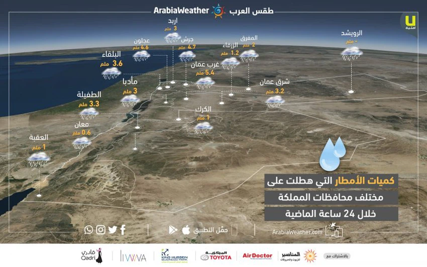
حيث كانت كميات الأمطار كالتالي: 

  • إربد: 3ملم
  • عجلون: 4.6 ملم
  • جرش: 4.7 ملم
  • البلقاء: 3.6 ملم
  • المفرق: 2 ملم
  • الزرقاء: 1.2 ملم
  • غرب عمان: 5.4 ملم
  • شرق عمان: 3.2 ملم
  • مأدبا: 3 ملم
  • الطفيلة 3.3 ملم
  • معان: 0.6 ملم
  • العقبة: 1 ملم


بإمكانكم معرفة احتمالية وفرص الأمطار في مناطقكم من هنا 

This article was written originally in Arabic and is translated using a 3rd party automated service. ArabiaWeather is not responsible for any grammatical errors whatsoever.
See More
Related News
Mild, spring-like weather through Tuesday, preceded by a rainy, stormy depression (to be classified later) starting Wednesday.

Mild, spring-like weather through Tuesday, preceded by a rainy, stormy depression (to be classified later) starting Wednesday.

A very cold air mass of polar origin is reaching the eastern Mediterranean. Will it be accompanied by snow?

A very cold air mass of polar origin is reaching the eastern Mediterranean. Will it be accompanied by snow?

A regional winter system will include several countries in the Eastern Mediterranean starting next Wednesday, God willing.

A regional winter system will include several countries in the Eastern Mediterranean starting next Wednesday, God willing.

Stormy and rainy air depression affects the Gaza Strip and the risk of sea waves entering the land increases

Stormy and rainy air depression affects the Gaza Strip and the risk of sea waves entering the land increases