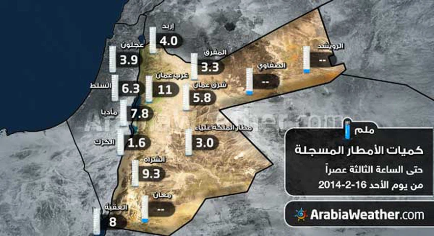
خارطة : كميات الأمطار المُسجلة حتى الساعة 3 من عصر الأحد

2014-02-16 2014-02-16T12:59:22Z
عمر الدجاني
عمر الدجاني
متنبئ جوي- مسؤول قسم الأخبار الجوية

موقع ArabiaWeather.com – عمر الدجاني- استمر تأثُر المملكة نهار الأحد بمُنخفض جوي مصحوب بكُتلة هوائية باردة، بحيث استمر تساقُط الأمطار في مناطق مُتفرقة و على فترات.


كميات الأمطار كانت في المُجمل بين الخفيفة و المتوسطة،و لكنها ذات أهميّة كبيرة فيما يخُص إعادة الرُطوبة للأراضي و ذلك بعد انحباس مطري طويل.


الخارطة توضّح كميّات الأمطار المُسجلة لدى بعض محطّات الرصد الجوي المُتوفرة في المملكة و ذلك منذ بداية تأثير حالة عدم الاستقرار الجوي مساء الجُمعة و حتّى الساعة الثالثة من عصر الأحد 16-2-2014.

This article was written originally in Arabic and is translated using a 3rd party automated service. ArabiaWeather is not responsible for any grammatical errors whatsoever.
See More
Related News
A dense dust storm has formed over northern Egypt and its arrival in the Kingdom is being monitored in the coming hours.

A dense dust storm has formed over northern Egypt and its arrival in the Kingdom is being monitored in the coming hours.

The map shows the areas most likely to receive rain from the upcoming low-pressure system.

The map shows the areas most likely to receive rain from the upcoming low-pressure system.

The low-pressure system is accompanied by abundant rainfall, reaching up to 100 mm in some areas.

The low-pressure system is accompanied by abundant rainfall, reaching up to 100 mm in some areas.

There are several reasons behind the upgrading of the classification of the upcoming low-pressure system to fourth place.

There are several reasons behind the upgrading of the classification of the upcoming low-pressure system to fourth place.