كميات الأمطار المُسجلة خلال الـ 24 ساعة الماضية

2018-01-24 2018-01-24T13:01:38Z
دائرة الأرصاد الجوية الأردنية
المصدر الحكومي لمعلومات الطقس و الأرصاد الجوية في المملكة الأردنية الهاشمية

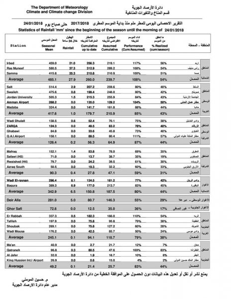
طقس العرب- تتأثر المملكة منذ أمس بمنخفض جوي رافقه هطول للأمطار على مناطق عدة في المملكة، حيث سجلت محطات الرصد الجوي التابعة لدائرة الأرصاد الجوية خلال الـ24ساعة كميات الأمطا التي هطلت من أمس حتى صباح اليوم الأربعاء:


وسُجل أعلى هطول في في راس منيف بـ 37,3 ملم، تلاها صما 25,3 ملم ثم اربد بـ 21,0، فيما بلغ أقل هطول في القطرانة بـ 0,3 ملم.


ولم تسجل مناطق عدة في المملكة أي هطول مثل الأغوار الجنوبية ومادبا ومطا عمان المدني والزرقاء


This article was written originally in Arabic and is translated using a 3rd party automated service. ArabiaWeather is not responsible for any grammatical errors whatsoever.
See More
Related News
Mild, spring-like weather through Tuesday, preceded by a rainy, stormy depression (to be classified later) starting Wednesday.

Mild, spring-like weather through Tuesday, preceded by a rainy, stormy depression (to be classified later) starting Wednesday.

Starting Wednesday, February 5, 2025: A winter system reaches the region for the first time this winter, resulting in a classified low pressure system followed by a cold wave.

Starting Wednesday, February 5, 2025: A winter system reaches the region for the first time this winter, resulting in a classified low pressure system followed by a cold wave.

A regional winter system will include several countries in the Eastern Mediterranean starting next Wednesday, God willing.

A regional winter system will include several countries in the Eastern Mediterranean starting next Wednesday, God willing.

Stormy and rainy air depression affects the Gaza Strip and the risk of sea waves entering the land increases

Stormy and rainy air depression affects the Gaza Strip and the risk of sea waves entering the land increases