Jordan: Active winds on Wednesday precede the impact of an air mass with temperatures much cooler than usual at night.
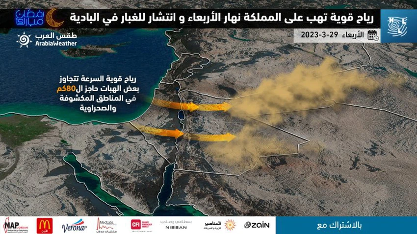
Weather of Arabia - The latest weather readings issued by the Arab Weather Regional Center for Weather Forecasts indicate that the Kingdom of Jordan is expected to be gradually affected on Wednesday by the secondary consequences of an air depression centered far from the Kingdom over Turkish territory. And this movement of the depression causes strong winds with gusts that may reach in some areas at a speed of more than 80 km / h, in addition to the spread of dust in the desert areas of the south and east of the Kingdom, God willing.
It is expected that temperatures will drop in the Kingdom on Wednesday, and thus become slightly lower than their usual rates for this time of the year, and the weather will be relatively cold in most regions, and moderate in the Jordan Valley, the Dead Sea and Aqaba, and gradually quantities of rain will appear. Clouds at low and medium altitudes.

A very cold air mass, unusual for its arrival in the region at this time of the year, rushes behind the depression and affects the Kingdom, starting from Wednesday / Thursday night
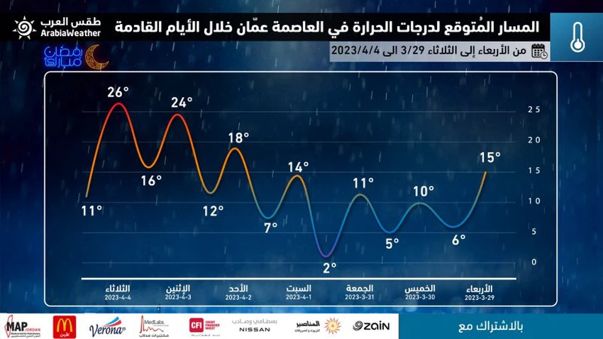
And the latest weather forecast maps in the Arab Weather Center indicate expectations of an air mass with much cooler temperatures than usual for the Kingdom behind the depression. This air mass moves in this way, and the path will drop sharply in temperatures, and this mass is accompanied by a change in the atmosphere to become as if it is winter. And the weather at night (i.e. the night of Wednesday / Thursday) turns remarkably cold in most regions of the Kingdom, and it is even very cold over the high southern mountain heights.
As for Thursday, it is expected that another significant decrease in temperatures will occur compared to what was the case in the past days, and it will become less than its usual rates for this time of the year by about 6-8 degrees Celsius, and the weather will be cold in general in most regions, and Amounts of clouds appear at low altitudes, and there is a possibility of scattered showers of rain in some northern and central regions, and northwesterly winds are brisk in general.
The effect of this air mass is expected to be evident, God willing, at night hours at the end of the week, as the weather at night (Thursday/Friday and Friday/Saturday night) is very cold in various regions, and very cold in the southern high mountain heights (Al-Sharah Mountains), so that Minimum temperatures drop there to approach zero degrees Celsius, with the possibility of frost forming over the high mountain elevations.

Recommendations from the Arab weather to deal with this atmosphere during the coming days:
- The activity of the wind speed, which exceeds the speed of some of its gusts on Wednesday, the barrier of 80 km / h, and therefore it is recommended to install the collectibles on the roofs of buildings and external properties, for fear of falling.
- Take care and caution while driving on desert roads as a result of the low horizontal visibility caused by dust and perhaps some dust storms.
- The need to pay attention to the unusual weather for this time of the year and the drop in temperatures to winter levels, especially in the night and early morning hours.
- Taking into account the return to wearing heavy clothes due to the cold weather.
- Considering the safe use of heating methods.
- Be aware of the dangers of frost formation over high mountain elevations, especially in the south (Al-Sharah Mountains).
God knows best and highest.
Arabia Weather App
Download the app to receive weather notifications and more..


