Friday | A second-degree air depression affects the kingdom, and a cold air front crosses at noon
Weather of Arabia - a further decrease in temperatures will occur during the day on Friday, so that very cold weather prevails over the mountainous heights and remarkably cold in the rest of the regions, and the impact of the air activity will temporarily decline during the morning hours, with the opportunity remaining ready for separate showers of rain in the north The front of the cold air front that will cross the kingdom at noon.
The winds will be southwesterly to westerly, moderate, and their intensity increases with the near crossing of the air front and becomes active in speed and accompanied by strong gusts of up to 100 km / hour in some areas, which leads to raising dust and dust in desert areas and roads.
A cold air front crosses the kingdom during the late morning and noon hours
The Kingdom gradually crosses during noon hours a cold air front, with which the Kingdom begins to be affected by the air depression classified as a second-class (normal) depression, where showers of rain start from the northern regions that extend rapidly towards the central regions and reach parts of the southern and eastern regions. Of varying intensity, and abundant at intervals in some areas, especially the northern and central regions, sometimes accompanied by thunder, and showers of hail that may be dense sometimes, and it is not excluded that snow showers will fall over the high mountainous heights in the north, central and south of the Kingdom for a short period, and this coincides with the formation of fog Dense over mountain heights as a result of crossing low clouds in contact with the surface of the earth.
A gradual decline in the effect of the depression at night!
The crossing of the cold air front is completed during the evening and night hours as the intensity of the rainfall weakens, and the Kingdom remains under the influence of moist western air currents rushing behind the depression, where the chances of rain and hail showers continue on separate parts, but with less severity and overallness than before. The appearance of light snow over the peaks of the Sharah Mountains in the event of availability of precipitation, as the weather turns to very cold, as frost and ice form in the southern desert and the peaks of the Sharah Mountains, with the continued formation of fog over the mountain heights as a result of crossing clouds touching the surface of the earth, and the fog is in the form of frozen fog Over the peaks of the Sharah Mountains.
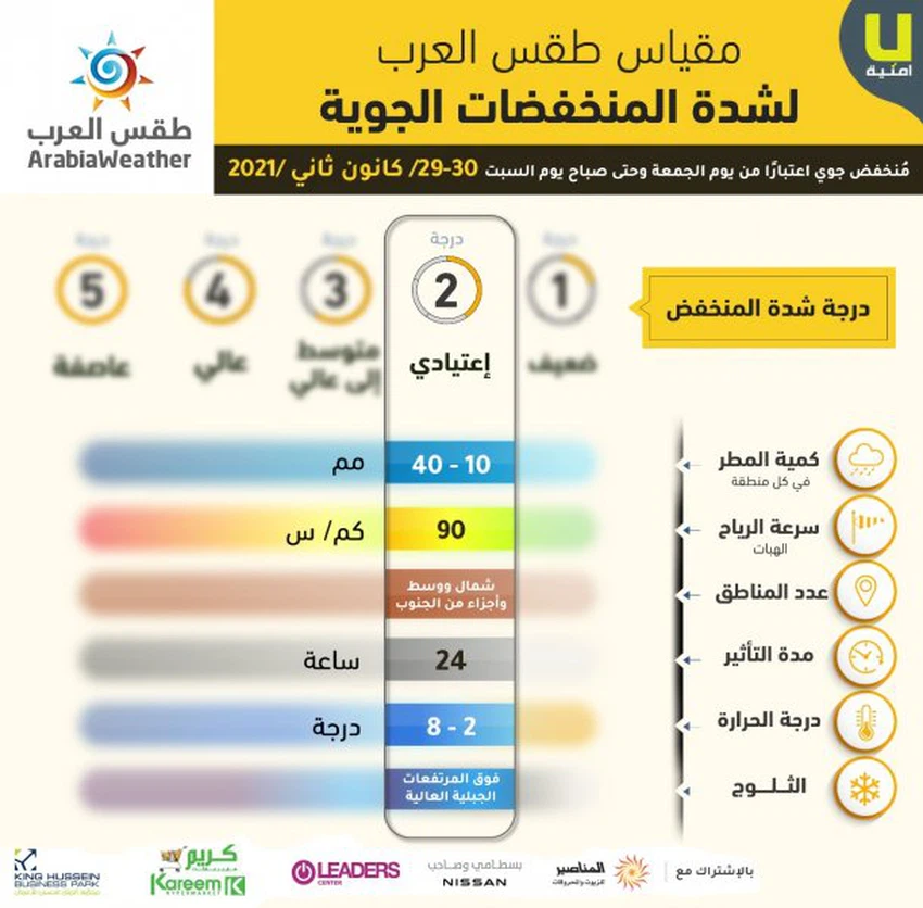 Infographic showing the most prominent effects of the second-class depression.
God knows.


Arabia Weather App
Download the app to receive weather notifications and more..