Saudi Arabia | A clear expansion in the area of the impact of the rainy situation on Thursday and Friday, and the Arab weather alerts
Arab Weather - Sinan Khalaf - The latest forecasts issued by the weather forecast cadre in the "Arab Regional Weather Center" indicate the possibility of the development of atmospheric instability affecting the Kingdom in terms of geographical area, to include more extensive areas during this day, Thursday and tomorrow, Friday, God willing. God
Concentrated in the center and east of the Kingdom
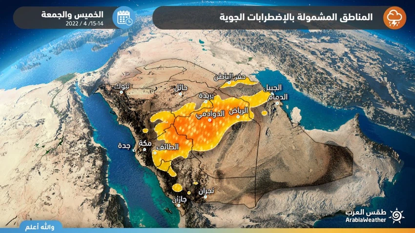
The expansion of the areas covered by the chances of rain on Thursday and Friday
In the details, the latest satellite images have begun to indicate the return of thunderclouds’ activity now in the western parts of the Riyadh and Qassim regions, more broadly compared to yesterday, Wednesday. Thunder from rain after God's will, accompanied by an activity of downward winds that raise dust and dust.

On Friday, it is expected that a tongue of cumulus clouds will form extending from eastern Taif through western Riyadh and the northern parts of it, to some internal parts of the eastern region, and some of these clouds may extend to affect the city of Riyadh, while the rains are expected to be light to medium in various regions. Affected areas, and may be accompanied by downward winds that raise dust and dust, and God knows best.
To read the best, download the Arabia Weather app from here
The science behind this air turbulence
This state of atmospheric turbulence comes as a result of the concentration of a shallow air depression in the atmosphere of central Saudi Arabia, in addition to the convergence of hot air in the Arabian Peninsula with colder air coming from the north, and the presence with activity of the Sudan depression, which leads to the emergence of air turbulence and the emergence of a state of atmospheric instability that is formed As a result, strong clouds accompanied by thunderstorms.
The weather forecast staff alerts us to:
- Intensity of downward winds associated with thunderstorms
- Risk of reduced or no horizontal visibility due to dust
Arabia Weather App
Download the app to receive weather notifications and more..


