Saudi Arabia | Fall 2024: Autumn rains expected at intervals with the possibility of extreme cases, especially during the second half of the season

From the Arab Weather Regional Center - The weather forecast cadre issued the climate forecasts for the Kingdom of Saudi Arabia for the next three months (October, November and December) for the year 2024, in a regular monthly update under the name "Seasonal Weather Bulletin", noting that the method of preparing these weather bulletins differs from other daily weather bulletins in that they are devoid of precise details, and their aim is to give a general picture of the season. The aim of presenting the forecasts is also to provide an initial idea of the expected temperatures and rainfall, as well as the most prominent expected climate phenomena.
Saudi Arabia | Fall 2024: Autumn rains expected at intervals with the possibility of extreme cases, especially during the second half of the season
The most prominent expected weather phenomena:
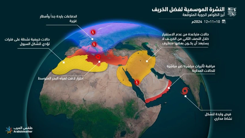
General situation:
-
The Red Sea depression is active at intervals, and the chances of rain are gradually improving, especially in the north and west of the Kingdom.
-
Increasing instability in the region during these details are available only to subscribers via the premium package
-
A decrease in temperatures and a gradual moderation in the weather during the day, with an increase in coldness at night during November and December, especially in the north of the Kingdom and the north of the central region.
-
Warning of the possibility of dust storms forming in some periods as a result of the approach of colder air masses from the north of the Arabian Peninsula, causing huge temperature differences and activity in wind speed.
-
Monitoring the possibility of tropical conditions forming in the Arabian Sea during October and November, which are naturally located south of the Arabian Peninsula in their possible paths if they form, and the Kingdom may be affected directly/indirectly if they form.
Map of rainfall deviation from general averages:
These maps are only available to subscribers via the premium package from here
Map of location and probability of tropical cyclone activity in the Arabian Sea
These maps are only available to subscribers via the premium package from here
Detailed weather conditions:
First month (October) 2024:
- Rain
- About the rate.
- Temperatures
- Convert to above average.
- Flood chance
- Weak in most parts, but moderate at times, especially in the southwest of the Kingdom.
- Description of air systems
- The upper air pressure system dominates most of the month, especially the first three weeks, leading to stable weather in most regions. This does not prevent thunderstorms from falling on some countries, especially the southwest of the Kingdom. Gradually, during the last third of the month, the activity of the Red Sea depression is expected to increase, leading to increased chances of cumulonimbus clouds and thunderstorms on some days, especially in the north and northwest of the Arabian Peninsula. There is also a good possibility of a tropical condition forming, especially east of the Arabian Sea.
Second month (November) 2024:
- Rain
- Below average.
- Temperatures
- Turn to warmer than average.
- Flood chance
- Generally low, but rises to medium on some days.
- Description of air systems
- The subtropical high is expected to gradually weaken, leading to a markedly moderate weather in large parts of the Kingdom, and the weather will become even colder at night, especially in the north of the Kingdom and the north of the central region. Also, the eastern winds, laden with moisture, will sometimes flow in conjunction with the approach of upper air depressions to the region, leading to the extension of rain to new areas, especially these details are available only to subscribers via the premium package
The third month (December) 2024:
- Rain
- Convert to higher rates.
- Temperatures
- About the rate.
- Flood chance
- Average overall / high in some areas.
- Description of air systems
- The chances of the arrival of air depressions in the upper layers of the atmosphere from the Arabian Peninsula improve , coinciding with the activity of the Red Sea depression, which leads to the possibility of the formation of more than one rainy weather condition, some of which may be extreme, and this allows the formation of floods in some areas and regions.
Climate situation (for specialists and interested parties):
This year, the Polar Vortex is experiencing an unusual situation, with an unusual weakness in the Polar Vortex system and a significant rise in temperatures above the usual average during the month of September. This is evident from climate models monitoring the presence of a high heat flow, which means that there is a large flow of energy from the lower to the upper regions of the atmosphere in the form of waves. This heat flow, although it occurs at high altitudes from the Earth's surface, has a great impact on changing the prevailing weather patterns on the Earth's surface and may play an important role in the future of the Northern Hemisphere's weather during the upcoming rainy season, God willing.
This unusual and early weakening of the polar vortex has been repeated in some previous years during the climate archive extending for nearly 50 years, and what is striking is that its early weakening in those years was statistically associated with a similar weakening in the months that followed and the winter, and one of the notable results of this is the recurrence of the sudden stratospheric warming (SSW), which means a sudden increase in temperatures in the upper layers of the atmosphere above the North Pole, leading to the descent of cold air to the middle and lower latitudes.
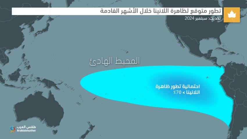
This coincides with what many global centers, including NOAA, are indicating, which now indicate a possible development of the La Niña phenomenon during the coming fall by more than 70%, which means a periodic decrease and cooling in the sea surface temperature in the eastern and central parts of the tropical Pacific Ocean. This phenomenon is also linked in archives to an increased possibility of a weakening of the polar vortex activity during the rainy season.
These climate indicators coincide with the exceptional warming witnessed by the Mediterranean Sea, with its temperature exceeding the average by more than 5 degrees Celsius in some areas, which will make the possibility of the emergence of extreme weather conditions likely during the coming fall, especially in the countries overlooking the Mediterranean Sea, and may form deep depressions that take on some of the characteristics of tropical systems.
Considering these indicators and other parameters such as the Indian Ocean Dipole (IOD), which is expected to remain neutral during the coming months, in addition to other important oscillations such as the AO and NAO, the location and intensity of the Madden-Julian Waves (MJO), and less influential for our region such as the PDO and others, and also considering the similar years, we can get a general picture of what the weather will look like in the Middle East during the coming fall, which can be summarized in the following points:
- The control of upper air masses over the Arabian Peninsula for not-so-short periods leads to stability in the atmosphere in most areas.
- Separating this, the approach of cold upper basins, whether from the northwest of the Arabian Peninsula or from the east of the Arabian Peninsula, leads to the occurrence of isolated cases of atmospheric instability, the pace of which increases more towards the second half of November and December, and it is not unlikely that some of them will be extreme.
- Numerical indicators indicate relatively good chances of the formation of more than one tropical system in the Arabian Sea during October and November, and it is not unlikely that parts of the southern Arabian Peninsula will be affected by these systems, especially since in recent years the Arabian Peninsula has been affected by tropical cases more than the first season.
- Temperatures are generally warmer than usual in large parts of the Arabian Peninsula, but this does not prevent cold waves from occurring at some times, especially as we enter the month of December.
How to prepare long-range weather bulletins
The issuance of these forecasts is based on studying the behavior of temperature and atmospheric pressure in the northern hemisphere, including the atmosphere and large bodies of water, and integrating these forecasts with global monitoring centers, to produce the highest possible forecast accuracy.
Arab Weather experts in the Scientific Research and Development Department have developed scientific methods that are the first of their kind in the Arab world and the world, as they rely on artificial intelligence in forecasting the coming months, by developing complex mathematical algorithms and equations to reveal the behavior of the atmosphere and correct long-term weather forecasts.
Unlike the daily weather forecast, these bulletins focus on the general weather conditions during a month, with the aim of knowing the deviation of rainfall and temperature from their general averages. Many meteorologists around the world are busy trying to solve the puzzle of achieving accurate seasonal forecasts by conducting a lot of research in this regard, in which the Arab Weather team participates in part.
The expected benefit of the quarterly bulletins is to help various sectors in early planning for the fall and winter seasons alike, especially the agricultural sector, which builds its agricultural plans on these indicators that sometimes help in reaping and achieving profits by exploiting this information, in addition to many other sectors that benefit from these expectations, such as the commercial sectors, the clothing sector, the energy sector, and others.
God is higher and more knowledgeable.


Arabia Weather App
Download the app to receive weather notifications and more..