Monthly weather forecast for February 2021
Jordan | February 2021: A normal winter month that fluctuates between stable and rainy periods with higher than average rain in general.
General situation:
- The month of February begins with stable, dry weather, and activity on the eastern winds.
- The need to use heating methods decreased in the second week of the month.
- A major change in the weather regulations in the third week, with the return of the chances of rain and cold.
- An activity that may be unique in the fourth week.
Chances of rain and the deviation of temperature from the general average during the month:
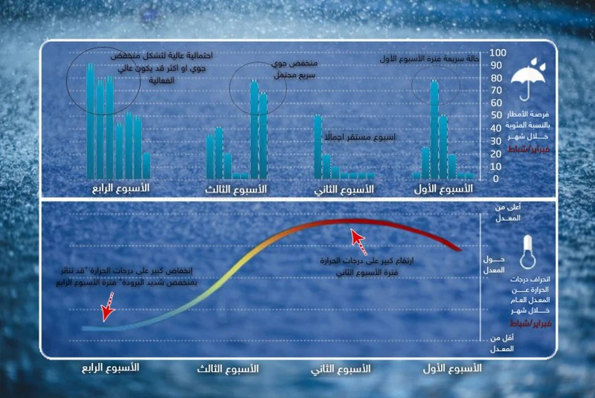
First week (1-7) February 2021:
- Rainfall: less than average.
- Temperatures: About above average.
- Chance of torrents: High
- Snow Chance: None
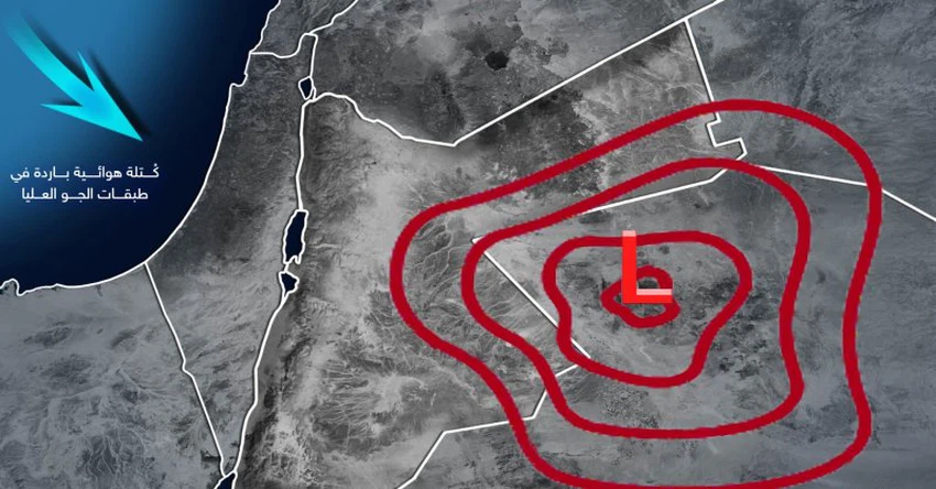
- Description of weather systems: It is expected that a stable atmosphere will prevail at the beginning of the first week, and temperatures tend to rise as a result of the Kingdom being gradually affected by the extension of the Red Sea depression, in the forefront of which are warm air currents in the surface layers of the atmosphere, and by the end of the week it is likely that it will rush to the eastern basin of the White Sea The Mediterranean, a cold and humid air mass in the high atmosphere, coinciding with an extension of the Red Sea Depression on the surface towards the region and the northern Arabian Peninsula, and this convergence will lead to the emergence of unstable weather conditions.
Second week (8-14) February 2021:
- Rainfall: below average (dry).
- Temperatures: Above average (warmth wave).
- Torrents Chance: None
- Snow Chance: None
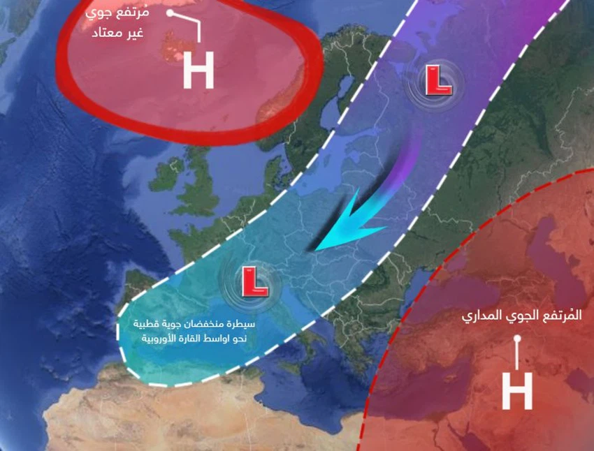
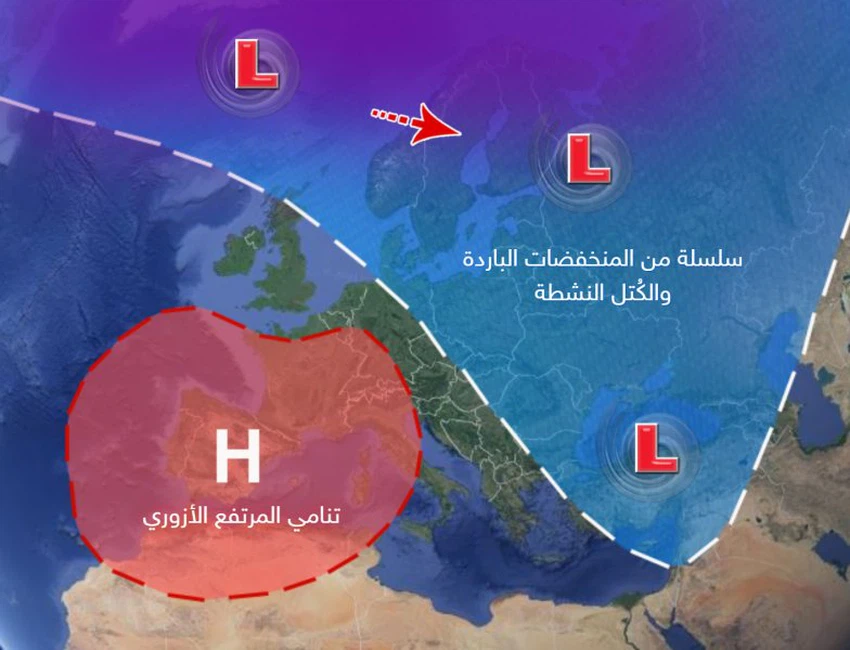
- Description of the air systems: parts of northern Europe and the island of Greenland are affected by a strong air altitude, this leads to a change in the distribution of air masses and the formation of negative weather patterns in terms of depressions for the Levant, including the Kingdom, where a polar mass is pushed directly towards large parts of the European continent, especially In its midst, while pressures prevail towards lower latitudes, including the Kingdom, as a result of the Kingdom being affected by the tropical air height on all layers.
Third week (15-21) February 2021:
- Rainfall: about above average.
- Temperatures: around below average.
- The chance of torrents: Medium
- Snow Chance: Weak
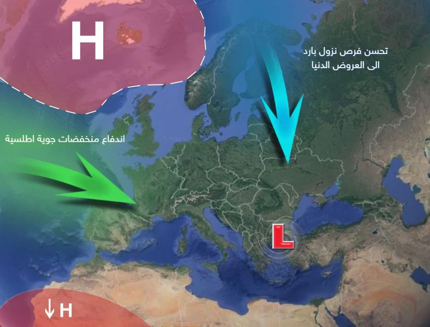
- Description of atmospheric systems: parts of northern Europe and Greenland continue to be affected by a solid atmospheric altitude, while the chance of some cold air basins extending at intervals towards the eastern Mediterranean is improving, coinciding with the possibility that we will be affected by Atlantic currents, which improve the chances of the formation of humid and cold depressions in Ocean island of Cyprus.
Fourth week (22-28) February 2021:
- Rainfall: about above average.
- Temperatures: below average.
- The chance of torrents: Medium
- Snow opportunity: medium opportunity on medium-rise mountains in the Kingdom.
- Description of weather systems: It is expected that the fourth week will be different, as it is expected that the temperatures will be cooler than the averages, while the amounts of rain are around their levels, with the chances of exceeding the rates in some areas, where it is expected that a radical change will occur in the air system represented by the growth of the air height towards North Africa And large parts of western and central European continent, and these depressions will be accompanied by cold to very cold air masses, so that the rains will return again at a higher rate to the region.
Climate situation (for professionals and interested parties):
During the last period, the negative pattern of the Arctic Oscillation (AO) and the North Atlantic Ocean Coefficient (NAO) prevailed, which negatively affected the eastern basin of the Mediterranean Sea. In the coming period, it is expected that the North Atlantic coefficient will trend between neutral and positive values. The Arctic coefficient reaches the negative values as it reaches its peak in the second week of the month, which means the stability of the polar masses in the middle shows, while in the direction towards the third week the coefficient tends to neutral values and this means the normal behavior of the atmospheric pressure values over the North Pole.
Also, Madden and Julian maps (MJO) indicate activity on the tropics and wet tides towards the Arabian Sea, Central Africa and the Red Sea, and this indicates the existence of an opportunity for rainy tropical activities towards the Levant, which may be in the form of instability.
The equatorial region of the Pacific Ocean is also experiencing a relatively high ocean surface temperature, with the persistence of the lanina phenomenon.
ArabiaWeather Company shall not be responsible for any republication. The materials published in the “Arabia Weather Blogs” in the various media, which puts anyone who publishes these blogs in the name of the Arabia Weather or quoting the Arabia Weather under liability and legal accountability.
Arabia Weather App
Download the app to receive weather notifications and more..


