In chronological order Details of a widespread case of air instability approaching Saudi Arabia
Weather of Arabia - The Kingdom began to be affected by a state of air instability during the day, Monday, and thunderstorm clouds abounded over the area of Hail and Hafar Al-Batin at noon on Monday, as southwesterly winds blew dust, working to lower horizontal visibility in the whole of the central and eastern region in the introduction to an air mass Cold in high temperatures, approaching the kingdom coming from Egypt.
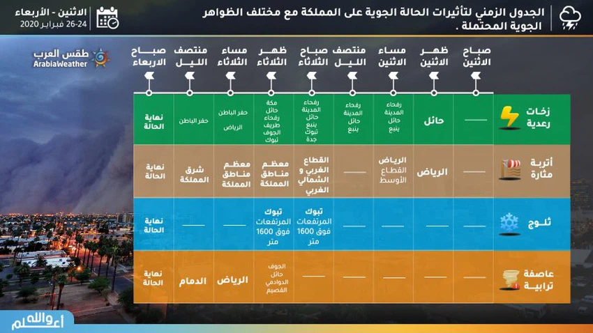
Monday afternoon .. thunderstorm showers in Hail and dust throughout the central region
Hail will be the first areas that will be affected by the state of air instability, and thunderstorms will spread throughout the region, extending during the hours of Monday evening to Hafar Al-Batin and south of the northern border in addition to parts of Medina and the chances of rain include the city of Yanbu.
The south-western winds are also active throughout the central region, working to stir up dust and dust, and significantly reduce horizontal visibility on Hail, Qassim, and the north and west of the Riyadh region, as well as extending to Hafar Al-Batin and Sharqia.
Aerial instability begins in the Tabuk region on Monday evening
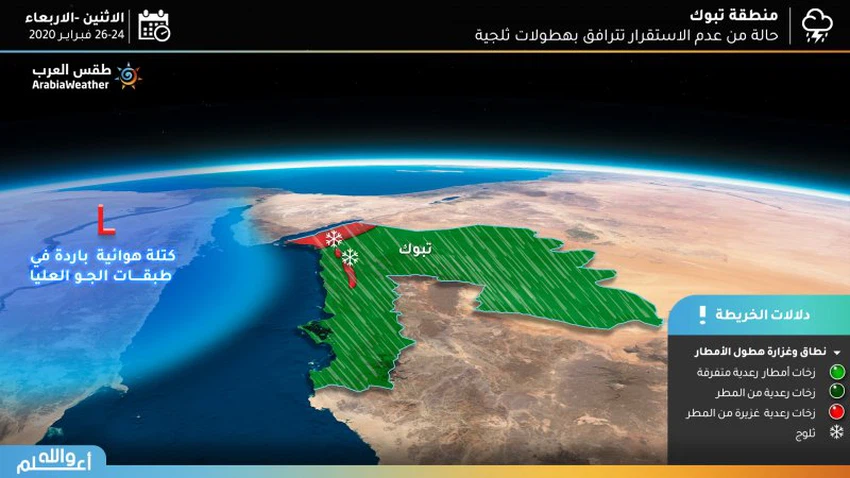
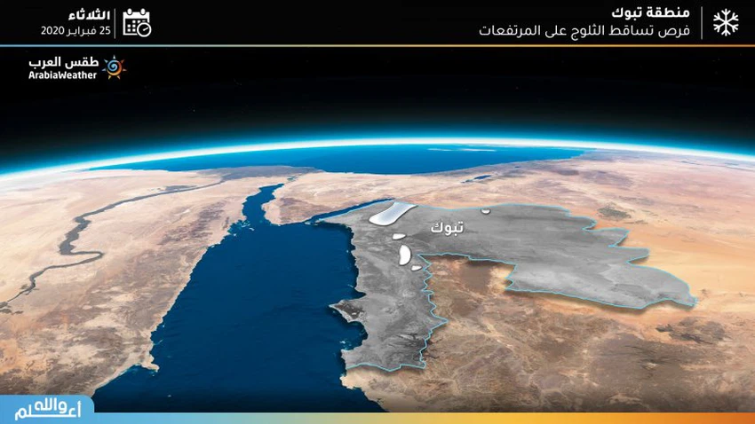
According to the current updates, Tabuk will be among the regions most affected by the state of air instability from Monday evening and continuing until Tuesday evening, and thunderstorms of rain will be heavy on the areas overlooking the Gulf of Aqaba and also the mountainous highlands in the region, and heavy snowfall on the top of Mount Almonds And accumulated in a way that may hinder the aspects of public life.
Rain showers reach the city of Jeddah and Makkah on Monday night / Tuesday and Tuesday morning
The city of Jeddah will not be immune to the weather, as the opportunity will be ready for thunderstorm showers from midnight on Monday / Tuesday and its chances will continue during the morning of Tuesday in the city, and the intensity of the situation on the city of Jeddah will be light in general, which may intensify for short periods especially dawn hours, Chances of rain gradually decrease in Jeddah city during Tuesday.
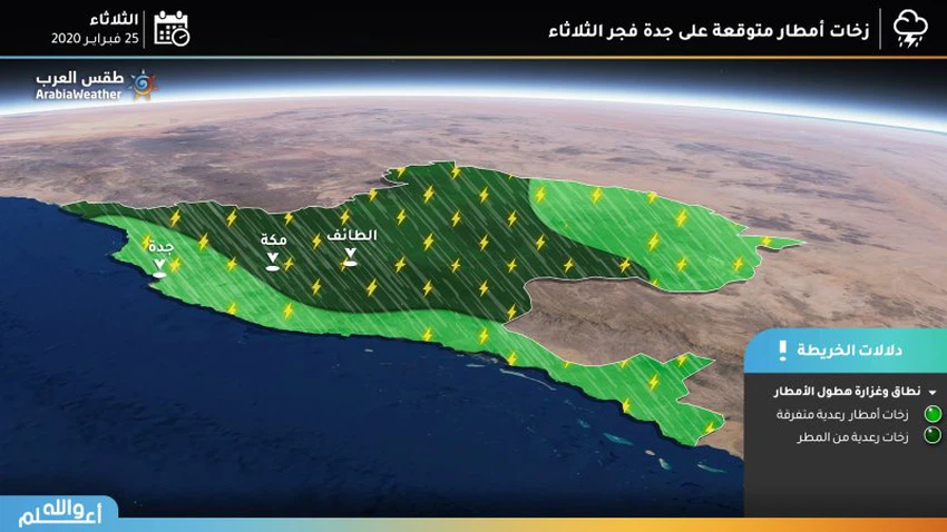
And thunderstorm showers in the holy city of Mecca on Monday night on Tuesday, and also on Tuesday may be accompanied by thunder sometimes and an activity in the speed of the winds that may provoke dust and dust.
Heavy thunderstorms on Al-Jouf and the northern borders on Tuesday
On Tuesday, the impact of the state of air instability widens to include Al-Jouf and the northern borders. There are heavy thunderstorms from the rain and the temperatures decrease significantly, where there is a high chance of forming torrents and high water levels in the roads.
Heavy dust and rain showers in the capital Riyadh on Tuesday evening
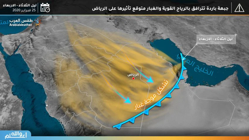
A cold air front begins crossing the airspace of the capital, Riyadh, on Tuesday evening, accompanied by a proliferation of medium-high clouds, which work to showers of rain, actively followed by the speed of the dramatic western winds. Significantly horizontal, in conjunction with a significant and significant decrease in temperature due to the start of a cold air mass transit.
Dust wave arrives in eastern Tuesday night
The dust wave reaches the eastern region on Tuesday evening, and it includes most of the regions of the region, including Dammam, with the hours of Tuesday / Wednesday night, and is accompanied by a decrease in the range of horizontal visions significantly and also a decrease in temperature.
As the cold front continues to move south, the dust wave reaches Al-Ahsa and additional areas from the south of Riyadh and the Empty Quarter on Tuesday night and Wednesday.
Wednesday .. End of instability and weather remains dusty
On Wednesday, the cold air front leaves the entire region of the Arabian Peninsula, and the chances of rain decrease in all regions with the weather remaining dusty in the Riyadh region, the eastern region and the Empty Quarter, and relatively cold weather prevails in most regions of the Kingdom except for the mountainous areas of Tabuk where there is a very cold atmosphere With freezing occurring hours on Wednesday morning.
Arabia Weather App
Download the app to receive weather notifications and more..


