In pictures: Lenticular clouds, the strangest forms of clouds
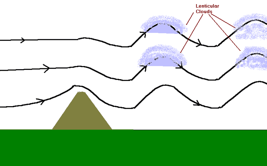
<p style=";text-align:left;direction:ltr">ArabiaWeather.com - Nasser Haddad - They are clouds with a very elongated lenticular or almond shape. The formation of these clouds (Lenticular clouds) is due to orographic reasons (topography), as they are often formed behind mountain barriers at the top of barrier waves, although they are sometimes formed in other These regions, and these clouds appear only in the clouds of Cirrus Cumulus, Cumulus Altocumulus, and Cumulus Stratocumulus.</p><p style=";text-align:left;direction:ltr"></p><p style=";text-align:left;direction:ltr"> It comes from the way they are formed, as they appear as lenses on top of each other, as they are frequently found in mountainous places. These clouds also appear in non-mountainous places during the passage of air fronts due to their association with shear winds.</p><p style=";text-align:left;direction:ltr"></p><p style=";text-align:left;direction:ltr"> <strong>How do these clouds form?</strong></p><p style=";text-align:left;direction:ltr"> The formation of this type of clouds requires the rush of moist air currents towards the mountains, where the chance of their appearance increases with the breadth of the mountainous area, and when the air currents pass on the other side of the mountain, air waves (standing waves) are produced, and as soon as they are associated with low temperatures and reach the dew point with them, then they begin The condensation process required for the formation of lenticular clouds.</p><p style=";text-align:left;direction:ltr"></p><p style=";text-align:left;direction:ltr"> <span style="line-height: 1.6em;">As a result of the nature of the movement of air waves that force the winds to move up and down in a wavy way, these clouds appear and disappear quickly. The scientific explanation for this phenomenon is that the downward wind movement leads to a decrease in the relative humidity levels, which causes the clouds to evaporate, and on the contrary, the relative humidity levels rise during the upward movement. That is, these clouds appear around the tops of the air waves.</span></p><p style=";text-align:left;direction:ltr"></p><p style=";text-align:left;direction:ltr"> See also:</p><p style=";text-align:left;direction:ltr"> <a href="http://www.arabiaweather.com/content/مع-بداية-يوليو-النينو-تعصف-بالعالم-وتسجل-القيمة-الاقوى-من-1998">With the beginning of July: El Nino storms the world and records the strongest value since 1998</a></p><p style=";text-align:left;direction:ltr"></p><p style=";text-align:left;direction:ltr"> <a href="http://www.arabiaweather.com/content/بالصور-غراب-جرئ-يمتطي-ظهر-نسر-أصلع">In pictures: a bold crow riding a bald eagle</a></p><p style=";text-align:left;direction:ltr"></p><p style=";text-align:left;direction:ltr"> <a href="http://www.arabiaweather.com/content/الدب-القطبي-يواجه-خطر-الانقراض">The polar bear is facing extinction</a></p>
Arabia Weather App
Download the app to receive weather notifications and more..


