Details of a strong rainy condition expected at the end of the week include these regions
Arab Weather - Sinan Khalaf - Our indications in Arab weather are increasing that the Kingdom, God willing, will be affected by a strong and comprehensive rainy situation at the end of this week, God willing.
Strong thunderstorms and potential sandstorms
Heavy thunderstorms in large areas on Friday and Saturday
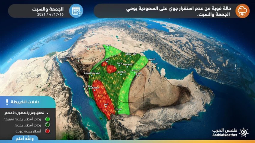
In details, the latest forecasts indicate that unstable weather conditions will emerge on Friday and Saturday, accompanied by heavy thunderstorms and hail showers on the heights of Jizan, Asir, Al-Baha and Taif, in addition to parts of the Hail and Qassim regions, and these clouds are actively accompanied by the downward winds that may form in their wake Dust waves in some areas.
The unstable weather conditions and the rainy thunderstorms that will accompany them extend to Hafar Al-Batin, Riyadh and the Medina region, but weak to moderate.
It should be noted here that this information is subject to improvement or regression, so we advise everyone to follow updates first to know all new developments in the rainy situation, and we also put in your hands these links for monitoring rain radar , and satellite images to follow the development of thunderstorms moment by moment.
Tropical humidity flowing towards the region
Causes of weather fluctuations in the region
An air high is concentrated over the waters of the Arabian Sea at the end of the week and moves away from the Arabian Peninsula, making room for the Red Sea depression to extend towards central Saudi Arabia in conjunction with the rush of large amounts of tropical humidity towards the Arabian Peninsula and the presence of remnants of a cold air mass in northern Saudi Arabia
ArabiaWeather warns, during the impact of the rainy situation, of:
- Intensity of thunderstorms
- The risk of torrential rains forming
- The intensity of downward winds associated with thunderstorms
- Danger of reduced horizontal visibility due to dust waves resulting from downwinds


Arabia Weather App
Download the app to receive weather notifications and more..