A state of rain stagnation in the countries of the Maghreb, amid warnings of the recurrence of sandstorms in the coming period
Arab Weather - The countries of the Maghreb are going through a phase of rain weakness since the beginning of the quadrangle, similar to the autumn season, during which the region received large amounts of rain, especially since the outputs of the numerical models issued by the Arab Weather Center indicate the continuation of the rainy season in February of 2022, and there will be Another rise in temperatures.
The current raindrop... Has it happened before?
There is no doubt that Algeria and several regions in the Maghreb suffer from rain confinement until this moment, as the region was not affected by any major weather conditions that contributed to "significant" rains during the previous 45 days, and in terms of numbers, it fell, for example, in the capital Algiers for a month January is approximately 20 mm. These quantities, when compared to normal rates (the amount of rain that is supposed to fall throughout January on the capital Algiers, compared to thirty years ago), represent approximately 23% of the monthly average only.
And instances of rain drop are repeated in the climate archives of Northwest African countries, where their climate is characterized by a large fluctuation of rain from year to year due to its occurrence between two climates. North Africa.
The reason for the state of rain stagnation that dominates the area
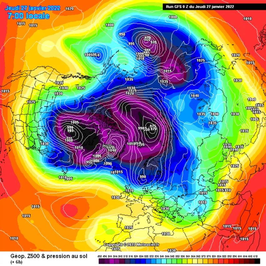
Rain blockage is defined as the phenomenon of rain stopping and interruption, and since the beginning of January until today, the rain has been almost cut off from the region. A strong air centered in all layers of the atmosphere, starting from the western parts as well as the northwestern parts of Africa, such as Algeria and Morocco in particular, all the way to the western European continent, while the eastern side of Europe and Russia are dominated by deep depressions associated with very low temperatures in many areas. These areas directly affect eastern and central parts of the Mediterranean.

But the remarkable thing during the past month is that this altitude has remained constant throughout the month, as the stability of the distribution of air masses and air systems from the Atlantic Ocean and the North Pole, God willing, led to the continued influx and transfer of cold air from polar high latitudes towards the east of the European continent, and then formed Atmospheric depressions in those areas, in complete contrast to the absolute control of the air altitude over the atmosphere of the Maghreb countries, and is accompanied by a warm air mass rushing from the African Sahara in a climate that is drier and warmer than usual.
Increasing frequency and intensity of sandstorms in the coming period!!
It is expected that the chances of dust and perhaps sand storms will increase in many areas as a result of the approach of cold and sometimes very cold air masses and the large thermal differences that occur and affect the values of atmospheric pressure, which contribute to the formation of some dust waves, especially since the coming period is characterized by large thermal differences and overlap and conflict between The effect of warm masses centered over the African Sahara and between the extension of cold/ultra-cold masses rushing across the Mediterranean.
With the lack of vegetation cover and the precipitation that makes the soil dry and loose with small and fine grains and particles, the wind can lift and carry it with ease and transfer it from one place to another in the form of wide sandstorms.
Monthly forecasts are not promising.. Remarkably less than average rain in February
The weather forecast cadre at the Arab Weather Center issued the monthly bulletin for the "Arab Maghreb countries", which included forecasts of rain significantly less than their average throughout the month, and temperatures are warmer than average in most regions, for more details here.
O Allah, give us rain, and do not make us despondent
Arabia Weather App
Download the app to receive weather notifications and more..


