A state of atmospheric instability in the eastern Mediterranean tonight may be accompanied by snowfall in limited areas

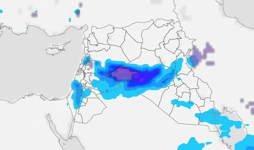
Arab Weather - Weather experts at the Arab Weather Regional Center said that the latest advanced computer outputs show that the eastern basin of the Mediterranean Sea is affected by unstable weather conditions, the effects of which will extend to the Levant, the northern Arabian Peninsula, and Iraq during this night and Sunday morning.
Unstable weather conditions affect parts of the Levant, northern Saudi Arabia and western Iraq tonight
Weather maps indicate that a cold air mass is rushing through the upper layers of the atmosphere towards the eastern Mediterranean, causing unstable weather conditions that bring heavy thunderstorms and active winds with hail in some areas, as the chances of rain increase, which may sometimes be heavy thunderstorms during the hours of tonight and Sunday morning. This requires attention to the heavy rain that will result in rising water levels and the formation of torrents, as well as strong thunderstorms and lightning.
Chances of snow showers tonight and Sunday morning in some areas of the Levant, Iraq and northern Saudi Arabia
As a result of the great surface cold, especially in the desert regions of the Levant, western Iraq, and northwestern Saudi Arabia, it is not unlikely that thunderstorms will sometimes be accompanied by temporary snow showers that may extend during the hours of Sunday morning to include major cities in Syria randomly, God willing.
Why are atmospheric instability conditions dangerous?
Atmospheric instability is usually accompanied by random rainfall, which leads to significant variation in the locations and intensity of rainfall within small geographical areas. This variation is a dangerous factor, as it contributes significantly to the flow of valleys and the formation of torrents that move between regions without the condition of rainfall in the same region. Atmospheric instability is characterized by rapid weather changes within very short periods.
Unstable weather conditions increase the chances of hail and sudden wind activity.
These cases are also accompanied by an increased likelihood of large hail and sudden wind activity. Dense dust belts may also form in desert areas before the onset of thunderstorms. It is expected, God willing.
And God knows best.


Arabia Weather App
Download the app to receive weather notifications and more..