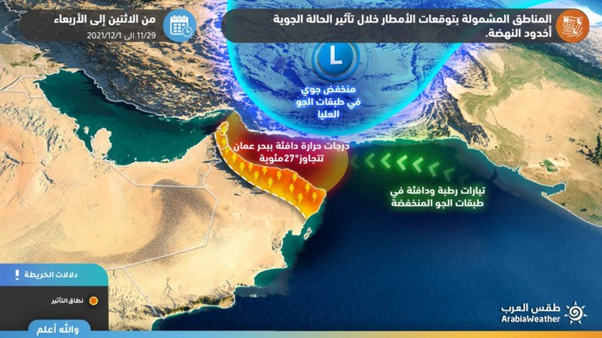
Sultanate of Oman | Details of the areas covered by the forecast of rain for the Sultanate during the impact of the rainy condition, the Renaissance Canyon
Arab Weather - The latest weather forecasts issued by the forecasting staff in Arab weather indicate that the Sultanate of Oman will be affected gradually, starting from Monday, in a rainy situation that is accompanied by many weather phenomena, such as rainfall and activity of downward winds that raise dust and dust, in addition to the heavy fall of papyri in some areas, God willing.
If you are browsing from your phone, you can download the Arab Weather application, which provides accurate weather forecasts for thousands of regions in the Sultanate, click here.
Details of the areas covered by the rain forecast
The rainy situation gradually begins on Monday
In the details, it is expected that weather fluctuations and rain opportunities in the Sultanate will start from daylight hours on Monday, starting from Musandam and the western coasts of the Sea of Oman, so that thunder clouds will be active, accompanied by rain, and that it will gradually extend during the afternoon and evening hours to parts of the heights of the Hajar Mountains and the neighboring areas, especially Western Stone and its environs.

It is expected that coastal areas will be more affected by unstable weather conditions on Tuesday, and by this we mean North and South Al Batinah, Muscat and to a lesser extent parts of South and North Al Sharqiyah, and expectations indicate that these areas will be subject to rainfall at times, accompanied by thunder sometimes, with an opportunity for valleys to flow and reefs, provided that the activity moves on the mountainous heights during the afternoon and evening hours and is accompanied by heavy cold sometimes, God willing.
The weather turbulence comes due to the gradient of an atmospheric depression in the northern part of the Sultanate of Oman through southern Iran, passing through the Sea of Oman, in conjunction with the rush of easterly winds loaded with quantities of moisture in the low layers of the atmosphere, which creates air turbulence in parts of the coastal areas overlooking the Sea. Oman and the Hajar Mountains, God willing.
Important alerts from Arabia Weather:
- Alert of thunderstorms in some areas.
- Warning of the possibility of the flow of valleys and reefs.
- Warning of the intensity of downward winds associated with thunderstorms.
Arabia Weather App
Download the app to receive weather notifications and more..


