Satellite images clearly monitor the snow accumulated over the mountains of the Kingdom

2023-02-11 2023-02-11T10:36:43Z
هشام جمال
هشام جمال
كاتب مُحتوى جوّي

Weather of Arabia - On Friday 10/2/2023, satellite images monitored snow covering the peaks of the governorates of Karak and Tafila, in addition to the heights of the governorates of Jerash and Ajloun, as shown in the map below.
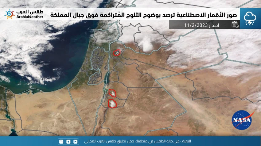
 

It is noteworthy that the Kingdom was affected by a fourth-degree depression from the afternoon of Monday 6/2/2023 until Wednesday 8/2/2023, which was accompanied by a very cold air mass, which caused snowfall and accumulation from the northern mountain highlands, and with a less sharpness from the central mountain highlands and later the Karak heights. And Tafila, and it is mentioned that the northern and southern mountainous heights enjoyed good accumulations of snow.

This article was written originally in Arabic and is translated using a 3rd party automated service. ArabiaWeather is not responsible for any grammatical errors whatsoever.
See More
Related News
 Weekly Bulletin: A stable week, with temperatures starting low and rising significantly to approach 20 degrees Celsius on Wednesday.

Weekly Bulletin: A stable week, with temperatures starting low and rising significantly to approach 20 degrees Celsius on Wednesday.

Warning of dense fog in the late night hours and Sunday morning in large areas of the Kingdom

Warning of dense fog in the late night hours and Sunday morning in large areas of the Kingdom

Why are California fires getting worse and more intense year after year?

Why are California fires getting worse and more intense year after year?

A low pressure system and a very cold polar air mass accompanied by heavy snowfall affect central and southern Europe.

A low pressure system and a very cold polar air mass accompanied by heavy snowfall affect central and southern Europe.