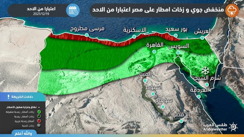
Egypt | Scattered rain on Sunday before crossing a strong cold front at night, accompanied by heavy rain in many areas
Arab weather - The latest updates on the air depression expected to affect Egypt's atmosphere on Sunday indicate that it is accompanied by a strong cold air front that is expected to cross the country with the hours of Sunday / Monday night, and bring abundant amounts of rain, God willing, towards the northern regions.
If you are browsing from your phone, you can download the Arab Weather application, which provides accurate weather forecasts for thousands of regions in Egypt, from here.
Cold air front crossing Sunday/Monday night
Thunder rain of varying intensity, sometimes heavy
Regarding the details, the weather will continue to be cold in the northern regions on Sunday, and some low clouds will flow on parts of the northern coast and Matrouh, accompanied by scattered showers of rain, with activity in the speed of southwest winds in the northern regions, with strong gusts sometimes exceeding the 60 km/h barrier. It works on high levels of dust in the atmosphere, especially on desert roads.
And with the hours of the night of Sunday / Monday, the country gradually crosses a cold, highly effective front, so that the rain begins to rain heavily in Matrouh, so that the weather will be cold, cloudy and rainy, God willing, in Matrouh. Gradually all areas of the North Coast, the Delta and Greater Cairo to parts of northern Upper Egypt, and the rains will be of varying intensity and heavy in some geographical areas, which leads to the formation of torrential rains and raising the water level on the roads in many northern areas.

There is an additional drop in temperatures on Monday, and they are several degrees below their rates for this time of the year, and cold weather prevails in the northern regions, and quantities of clouds gradually multiply at different altitudes, and as a result, showers of rain and hail are expected, God willing, in several areas. From northern Egypt, it includes large parts of the northern coast, the Delta, Sinai, Matrouh, and Greater Cairo, all the way to parts of northern Upper Egypt. The rains are of varying intensity, heavy at times, which may lead to the formation of torrential rains and high water levels on the roads.
It is accompanied by an active southwesterly blowing speed over the northern regions, with strong gusts sometimes exceeding the 70 km/h barrier, working to raise the levels of dust in the atmosphere, especially on desert roads, and also with thunderstorms, especially in coastal areas, and heavy hail showers sometimes, And high chances of snow showers on the mountain peaks of St. Catherine.
It is expected that the upcoming depression will bring large amounts of rain to additionally support the current distinguished rainy season, and many regions in the Kingdom, after the decline of this depression, will achieve their general cumulative average, God willing.
During the period of impact of this depression, Arabia Weather recommends:
- Attention to the possibility of rising water levels on the roads, and torrential rains may form in some areas.
- Pay attention while driving on the roads due to the risk of slipping due to hail.
- The necessity of fixing the external holdings due to the severity of the expected wind speed, and reducing the driving speed of large vehicles on external roads.
- Attention to the dangers of sand storms on desert roads and their impact on horizontal visibility.
- Attention to the dangers of high waves in the Mediterranean due to strong southwesterly winds and the effects of this on maritime traffic.
- Observe the safe use of heating equipment.
Arabia Weather App
Download the app to receive weather notifications and more..


