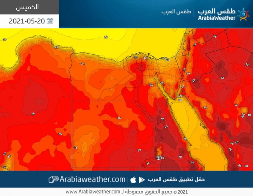
Egypt | More rise in heat and dusty winds activity in parts of the country on Thursday
Arab Weather - Another rise in temperatures is occurring due to the increasing influence of the upper altitude over Egypt, to become higher than its rates for this time of year by 5-6 degrees Celsius.
Another rise in temperatures
Generally hot and dusty weather in these areas
The temperature rises Thursday in all governorates and cities of Egypt, where moderate to relatively hot weather prevails on the northern coasts and the coasts of the Red Sea, and is hot in the Delta, Greater Cairo, the cities of the Canal, and central and southern Sinai, and is very hot in the rest of the regions, and the winds will be north to northeasterly moderate in speed, sometimes active In parts of Greater Cairo, the Delta, northern Upper Egypt, the canal cities, and the coasts of the Gulf of Suez, and they cause dust and dirt in Matrouh, Sinai, North Upper Egypt and Aswan, and show dispersed clouds at medium and high altitudes, while the weather is generally moderate to gentle in most regions of the republic at night.

Chances of fog formation in the northern parts
After the late night hours
Fog is expected to form in the northern parts of the republic on Sunday night / Monday and Monday morning, as surface moisture levels rise and light fog will form on parts of the northern coasts, north and central Sinai and the canal cities.
The state of the Red Sea and the Mediterranean
A turbulent sea and the rising waves of the Red Sea
The waves are medium to high in the Red Sea and reach a maximum height of two meters, which may lead to a partial disruption of navigation and some marine activities, especially in the Gulf of Suez, while they are light to medium in the Mediterranean, which may lead to the regularity of all marine activities.
Important recommendations that are recommended to be taken seriously:
A set of important recommendations that must be taken seriously in dealing with such an atmosphere can be summarized as follows:
- Avoid exposure to the sun, especially during the afternoon and afternoon hours.
- Drink plenty of cold fluids and soft drinks throughout the day.
- Be careful not to leave sterilizers and any flammable materials inside the vehicles.
- Be careful not to leave children inside the vehicles, even for a few short periods.
- The risk of a decrease in the horizontal visibility due to dust and dust in some areas.
- Risk of additives in patients with respiratory tract and eyes due to dust.
- The risk of reduced horizontal visibility due to fog and clouds touching the surface of the earth in parts of the northern regions.
Arabia Weather App
Download the app to receive weather notifications and more..


