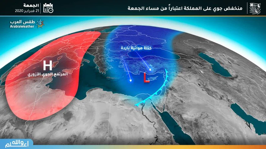
A new air depression affects the kingdom on Friday evening and Saturday
Weather of Arabia - Large areas of the European continent and North Africa are still under the influence of an air in all layers of the atmosphere, working on the prevalence of a warmer and drier atmosphere than usual in all of these regions, and rare and unusual during the coming period.
It is expected that a new cold and wet air mass will rush through the eastern Greek islands and the Aegean Sea towards the eastern basin of the Mediterranean Sea, and with the presence of other favorable conditions, an air depression will be established centering on the island of Cyprus and then moving in the northeast direction, on Friday evening.
How will the new depression affect the kingdom?
This depression is accompanied by a cold and effective front, which will cross western Syria, Lebanon and northern Palestine strongly, but as a result of the movement of this depression quickly in the northeast direction, this makes the Kingdom a last stop in the path of this depression.
Consequently, it is expected that this air depression will carry a "first / weakest" rating on the scale of the "Arab Weather" classification of the severity of the air depressions, which reaches to the fifth most severe and exceptional degree.
This cold front will cross, according to the latest developments, at midnight on Friday / Saturday, where rain clouds will multiply and rain will be organized, God willing, which will begin with evening hours, in the north and center of the Kingdom and the southern mountainous highlands.
These rains are accompanied by showers of hail and form fog over the highlands.
However, this cold front will cross quickly, with the air efficiency declining on the morning of Saturday, with the opportunity to receive separate showers of rain in the north and central of the Kingdom, God willing, with continued fog forming on the highlands and strong winds blowing west winds.

Arabia Weather App
Download the app to receive weather notifications and more..


