Important | Details of the second class (medium) air depression

2021-03-10 2021-03-10T13:58:31Z
هشام جمال
هشام جمال
مُحرر أخبار جوية

Weather of Arabia - According to the numerical weather outcomes, the current Khamenei depression is expected to turn into a second (medium) air depression, which brings many weather phenomena, with more complete details from here.


The most prominent impacts expected of this depression:

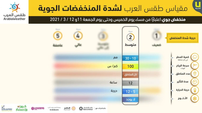
  1. Rain Amount (in each area): 10-30mm.
  2. Wind gusts speed: 100 km / h.
  3. Number of regions: all regions.
  4. Effect duration: 12 hours.
  5. Temperature: 5 - 12 degrees.
  6. Snow: no.

God knows.

This article was written originally in Arabic and is translated using a 3rd party automated service. ArabiaWeather is not responsible for any grammatical errors whatsoever.
See More
Related News
Jordan | As temperatures rise, there are signs of weather instability on this date

Jordan | As temperatures rise, there are signs of weather instability on this date

In the fall, a winter-like atmosphere will enter several regions of Europe, accompanied by a warm air mass rushing towards the eastern Mediterranean.

In the fall, a winter-like atmosphere will enter several regions of Europe, accompanied by a warm air mass rushing towards the eastern Mediterranean.

Latest Updates: Tropical Storm Helene will develop into a hurricane tomorrow and move at full force towards the coast of South America, accompanied by massive amounts of rain and strong winds.

Latest Updates: Tropical Storm Helene will develop into a hurricane tomorrow and move at full force towards the coast of South America, accompanied by massive amounts of rain and strong winds.

Europe | Rainstorms expected in Spain, France and Portugal in the coming days

Europe | Rainstorms expected in Spain, France and Portugal in the coming days