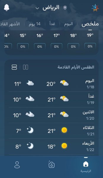
A cold wave will affect several regions of the Kingdom, including Riyadh, in the middle of the week.
Arab Weather - The latest weather maps indicate that the Kingdom of Saudi Arabia will be affected in the middle of this week by a cold wave resulting from an extension of the so-called Siberian high, which will lead to a drop in temperatures in several areas of the Kingdom, including Riyadh.
Details of the cold wave expected to affect the Kingdom in the middle of the week
God willing, the cold air mass is expected to affect the north of the Kingdom on Tuesday, with temperatures dropping and becoming colder than usual in the northern border regions, Al-Jawf and Hail. Cold weather will prevail during the day in those regions, but it will be very cold at night with temperatures approaching zero degrees Celsius, with frost forming in a number of areas.
During the hours of Tuesday/Wednesday night, the effect of the cold wave extends to the eastern and central regions, including Riyadh, so that the weather turns to become very cold in those regions and temperatures drop to 3 to 10 degrees Celsius in those regions, as monitored by the Arab Weather app .

The effect of the cold wave is expected to continue on Wednesday, God willing, as temperatures will remain several degrees cooler than their usual rates, and the weather will be cold during the day in various northern, central and eastern regions, while it will turn very cold at night.
What is the Siberian High?
The Siberian High is a large mass of cold air that gathers over the Siberian region of northeastern Eurasia. Because the pressure of the cold air is high, high pressure prevails in the areas it affects, and the temperature drops. Extreme cold and dryness are among the most important features of the Siberian High because it is formed as a result of severe surface cooling over continental areas far from marine influences.
The Siberian High is responsible for the severe cold and dry waves in large areas of Europe and Asia, and its effect may cross the Arctic Ocean to affect Canada and the United States.
The Siberian high is produced by the process of radiation cooling of the Earth's surface, and its formation is contributed to by the dryness of the air above the continental region far from marine influences and humidity. The drop in temperatures in the areas where it forms to below zero degrees Celsius for several months causes the atmospheric pressure at its center to rise, sometimes reaching 1055 millibars. The cold, dry air is heavy, so the surface atmospheric pressure rises despite the extreme cold.
The actual period or actual season for the recurrence of the Siberian High extends between the months of September and March, as September represents the beginning of the emergence of the Siberian High coinciding with the apparent perpendicularity of the sun to the equator, and the beginning of its movement towards the south. The further the sun moves towards the south, the more its recurrences and durations increase, meaning that it intensifies and expands in the winter. March represents the actual end of the effects of the Siberian High, and the transfer of its effects northward, until its recurrences cease during the summer months. Its recurrence coincides with the presence of a large number of pressure systems, but it forms an air barrier from the east that prevents the systems moving eastward from penetrating.
And God knows best.
Arabia Weather App
Download the app to receive weather notifications and more..


