A deep low pressure system is now forming between Italy and Greece, accompanied by strong winds, heavy rains, and effects on Libya.
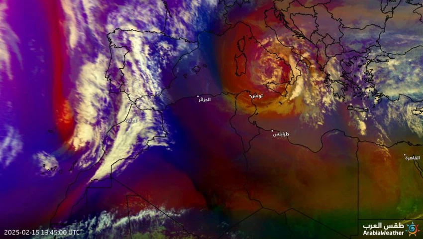
Arab Weather - The latest images recently captured by the remote sensing systems of the Arab Weather Regional Center monitor the formation of a deep air depression currently centered over the Tyrrhenian Sea between the Italian islands and Greece, and dense bands of cumulonimbus clouds laden with heavy rains revolve around its center, coinciding with the blowing of very high-speed winds, which according to the latest readings reached a speed of nearly 80 km/h, and the gusts exceed that by much, causing severe disturbance of the waves within the framework of the centering of this air depression.
The depression will deepen further tonight and Sunday morning and will directly affect Greece.
Weather forecasters at the Arab Weather Regional Center said that the latest numerical simulation models indicate that this low pressure system will deepen and develop further during the hours of tonight, dawn and Sunday morning, coinciding with its movement eastward towards Greece, where the direct effects of this weather system will be on large areas of Greece, especially its southern parts. It is expected, God willing, that the low pressure system will cause dense bands of cumulonimbus clouds to move, accompanied by heavy to very heavy rains, accompanied by strong thunderstorms and heavy hail showers, which increases the possibility of flooding and rising water levels. In addition, high-speed winds will blow, reaching gusts of nearly 100 km/hour, causing severe disturbance of sea waves, with waves reaching a height of 3-5 meters, especially in the depths.
The effects of the weather system on northern Libya in the form of strong winds and sometimes thunderstorms
During the passage of the low pressure system tonight and Sunday, it is expected that the northern Libyan territories will be affected by the consequences of the weather system, in the form of strong winds blowing on the northern coasts, specifically Benghazi and its surroundings, with clear disturbance of the waves of the Mediterranean Sea near the coasts and in the depths. It is also not excluded that scattered showers of rain will fall in parts of the coastal region as a result of the passage of some rain clouds from time to time.
The depression is caused by a very cold air mass rushing towards the Mediterranean Sea and does not acquire any semi-tropical characteristics.
The weather forecasting staff at the Arab Weather Center confirmed that the low pressure system currently over the sea waters does not have any semi-tropical characteristics, but rather resulted from the rush of a very cold air mass towards the waters of the Ionian Sea (which is considered part of the Mediterranean Sea) and due to the sharp temperature differences between the cold air coming from the European continent and the warmer sea surface temperature, the low pressure system was formed by God’s will.
Satellite images show a low pressure system in the central Mediterranean


Arabia Weather App
Download the app to receive weather notifications and more..