A low pressure system affecting the western Mediterranean is pushing a warm wave to the eastern Mediterranean and the Levant (details)
")
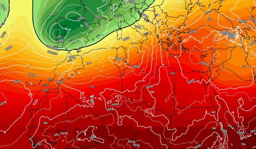
Arab Weather - The countries of the eastern Mediterranean basin, specifically the Levant, are affected by a warm wave starting Tuesday and continuing for several days resulting from the expansion of a strong high pressure system in the upper layers of the atmosphere, coinciding with the flow of air currents with warmer than usual temperatures in the layers of the atmosphere close to the surface, and a warm spring atmosphere prevails in all regions.
A strong low pressure system over central and southern Europe, reaching Morocco, accompanied by heavy rains
God willing, the Azores high is expected to extend towards the northeastern Atlantic Ocean, resulting in a break in the polar jet stream towards central and southern Europe, reaching North Africa, specifically the Maghreb countries. God willing, this weather situation will result in the formation of a deep low pressure system that will bring heavy rain to low-lying areas, while the same weather system will result in heavy snowfall over mountain peaks, especially in Italy, Greece and surrounding countries.
Strong low pressure system over Europe pushes warmth towards eastern Mediterranean, delays rain
Scientifically, the weather systems in the Northern Hemisphere are linked to each other, as the relationship between the shape of the weather systems in southern Europe and the Maghreb countries is inverse. In order for the countries of the eastern Mediterranean basin to be affected by depressions and winter systems, a high must be centered over southwestern Europe and the Maghreb countries.
But in the current situation, the rush of cold winds towards the aforementioned regions leads to the displacement of warm winds towards the countries of the eastern Mediterranean, which results in a delay in rainfall and the dominance of high-pressure systems that prevent the advance of winter depressions towards the region.
God knows best.


Arabia Weather App
Download the app to receive weather notifications and more..