A new tropical wave increases the chances of rain in the Sultanate of Oman, the UAE, Saudi Arabia and Yemen
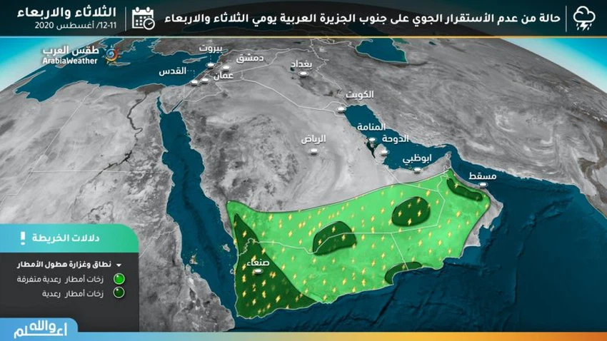
Arab Weather - Sinan Khalaf - Our latest weather forecast in ArabiaWeather indicates an increase in the chances of rain in the southern part of the Arabian Peninsula on Tuesday and Wednesday, due to the influx of tropical moisture coming from the Arabian Sea that creates unstable weather conditions.
What areas are covered by the tropical wave and the chances of rain?
This expected air turbulence results from the concentration of an atmospheric depression in the high air layers in the Arabian Sea, which pushes humid winds in the middle and high air layers towards the Sultanate of Oman and the interior parts of the Emirates, Saudi Arabia, "the Empty Quarter, Najran" and Yemen.

First: the Sultanate of Oman
God willing, cumulonimbus thunderstorms will continue to form on the heights of the Hajar Mountains in the coming days, to increase in strength and comprehensiveness as of next Thursday, as it is expected that cumulonimbus thunderstorms will form on the mountain heights and that medium and heavy rain will fall, accompanied by an activity of downward winds and hail showers .
Second: The Emirates
The chances of rain are high in the inner parts of it, especially the city of Al Ain, associated with the formation of dust, which may flow towards some coasts.
Third: The Kingdom of Saudi Arabia
Cumulus clouds proliferate in large parts of the southern and southwestern sector of the Kingdom, and include the Empty Quarter, the far south of the Riyadh region, Najran, and parts of the Jizan heights. These clouds, God willing, are accompanied by a thunderstorm of rain that is of a local, random, and severity.
Fourth: Yemen
In Yemen, it is expected that most of its regions, especially the mountainous sectors of it, will be affected by these weather fluctuations, as it is expected that cumulonimbus clouds will form and rain in abundance, sometimes accompanied by showers of cold.
Arabia Weather App
Download the app to receive weather notifications and more..


