A state of atmospheric instability and thunderstorms will cover areas of Greater Cairo in the coming days
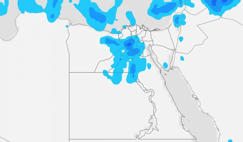
Arab Weather - Weather experts at the Arab Weather Center said that the latest outputs from the computer simulation indicate that Egypt will be affected on Wednesday and Thursday by a state of atmospheric instability, so the chances of rain will rise again, especially in the North Coast areas, and it is not unlikely that the rain will be thunderous and heavy, causing water pools.
Moderate weather during the day in the coming days, with temperatures in the twenties in various regions
The coming days will see cold weather in the morning hours with the formation of mist in some northern areas. It is possible that the mist will be dense and reach the level of fog. However, the rest of the day, temperatures tend to rise and be higher than usual for this time of year. Moderate weather will prevail in various parts of Egypt, while it will be warm in the southern regions of Egypt, specifically the Upper Egypt governorates. The winds will be northwesterly, moderate in speed, and sometimes active.
A state of atmospheric instability will affect the north of the country on Wednesday and Thursday, accompanied by thunderstorms.
The northern regions of Egypt will be affected by a state of atmospheric instability on Wednesday and Thursday, especially in the afternoon hours, so clouds will increase and showers of rain will fall on the northern coast areas extending towards the northern part of Lower Egypt and some inland areas. Some showers will be heavy and accompanied by thunderstorms, causing water pools and rising water levels.
Chances of some rain showers extending to some parts of Cairo
During the afternoon and evening hours of Wednesday, there is a possibility that rain showers will extend temporarily towards neighborhoods of Greater Cairo, with generally less intensity, and may be accompanied by thunder. Chances of some rain showers remain until the early night hours, before they gradually begin and the chances of rain weaken and resume on Thursday, God willing.
Heavy fog with late night hours of Thursday/Friday night and Friday morning
God willing, dense fog is expected to form on Thursday/Friday night and Friday morning, reaching the level of mist, causing a decrease and perhaps a complete lack of horizontal visibility. The fog forecast includes large areas in the north of the country, especially agricultural and express roads and those close to water bodies, in addition to the north of Lower Egypt extending towards neighborhoods of Greater Cairo. The weather will be cold in general.
Fog begins to form during the late night and dawn hours, and continues until the morning hours before it begins to gradually disappear due to sunrise and rising temperatures.
God knows best.


Arabia Weather App
Download the app to receive weather notifications and more..