A very cold polar air mass is pushing into Eastern Europe, and snow is present, coinciding with the vernal equinox.
Arab Weather - Meteorologists at the Arab Weather Regional Center said that the latest computer simulation readings indicate the formation of a strong high pressure system over large areas of the European continent, leading to the rush of an extremely cold air mass of polar origins toward eastern Europe toward the end of this week, marking the end of winter and the beginning of spring, astronomically speaking.
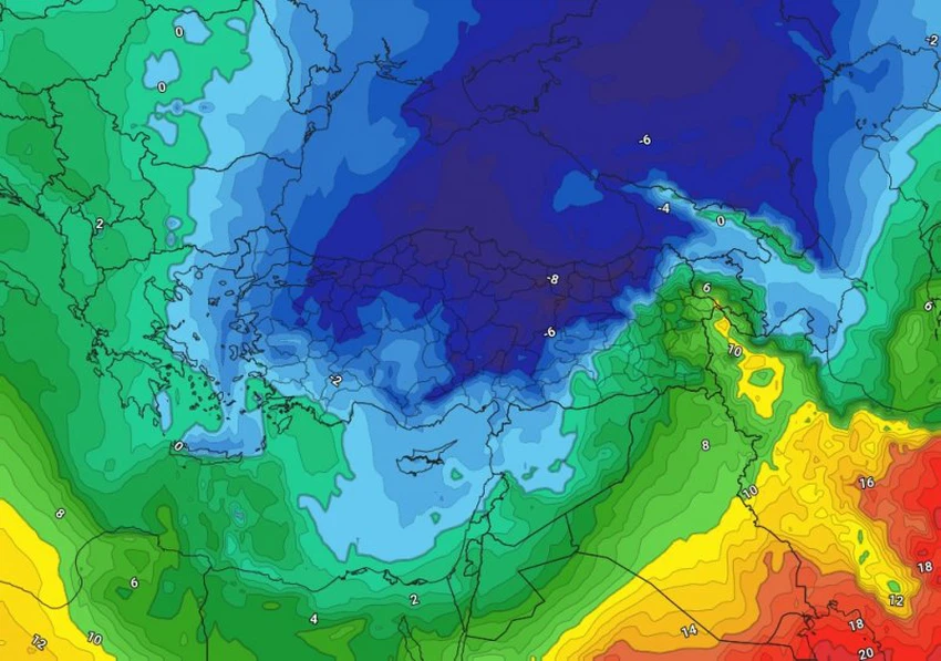
In detail, experts at the Arab Weather Center indicated that as a result of the formation of a strong high pressure system across large areas of the European continent, the polar jet stream is undulating, and an extremely cold air mass of polar origin is rushing towards eastern Europe. According to the data, regions of Eastern Europe, including Turkey, will be affected by this polar mass, leading to a significant drop in temperatures and the prevalence of very cold and rainy conditions, which may be accompanied by snowfall in large areas, including most of Turkey.
The impact of these polar winds on the eastern regions of the European continent coincides with the astronomical end of winter and the beginning of spring. The vernal equinox in the northern hemisphere will fall on Thursday, March 20, God willing.
A snow wave coinciding with the vernal equinox affects Türkiye and eastern Europe.
The polar air mass is expected to be accompanied by a rush of large amounts of moisture, bringing heavy rains that will quickly turn into snow across all mountainous areas, including parts of coastal regions. As a result of the polar winds flowing behind the low-pressure system, widespread snowfall will occur in most Turkish cities, especially in the central, northern, and eastern regions. Heavy snow is expected at times, resulting in significant snow accumulations coinciding with the vernal equinox.
And God knows best.


Arabia Weather App
Download the app to receive weather notifications and more..