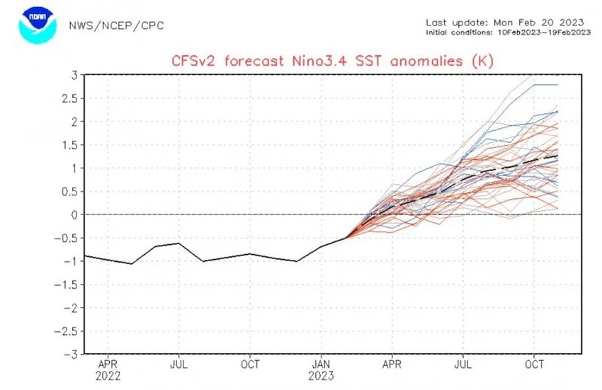
After her absence for several years, preliminary indications of the growth of the `El Nino` phenomenon in the coming months
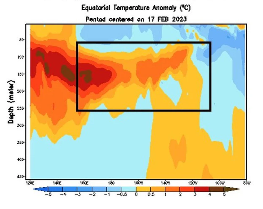
Weather of Arabia - Global dynamic and statistical models specialized in studying the temperature of the Pacific Ocean, headed by the National Oceanic and Atmospheric Administration (NOAA) indicate expectations of a gradual growth of the El Nino phenomenon during the coming months, as the same models indicate that the distribution of Pacific Ocean warming is trending To get rid of the La Nina pattern, God willing, after it lasted for three consecutive years.

Indeed, meteorological systems, in addition to the so-called "TAO" ships, are showing a continuous rise in temperatures over the eastern tropical region in the Pacific Ocean, and this indicates that the coming months will carry more rises in temperatures, which means that the eastern trade winds will contribute. The cooling of the tropical region of the Pacific Ocean will weaken greatly, and the coming months may turn westerly, which raises the temperatures of the tropical Pacific region.

El Nino phenomenon and its effect on the atmosphere
The El Nino phenomenon occurs at a rate of every two to five years, and it represents a temperature "anomaly" that rises by more than half a degree Celsius in the water temperature of the tropical region of the Pacific Ocean for a certain period of the year and for a period of not less than three months.
And El Nino is one of the most important weather phenomena in the climate, which has been statistically proven to indirectly affect the atmospheric pressure system in the world, as it causes changes in the movement of the atmosphere starting from the equatorial region over the Pacific Ocean, which transmits changes to large air masses, and then this is reflected To weather phenomena in various regions of the world, causing severe weather fluctuations in weather phenomena between waves of floods and droughts in various parts of the world and consequently large economic losses.
- It affects the movement of jet streams (which are very fast air currents in the upper climatic layer of the atmosphere) and leads to an increase in its movement and dynamism, and thus causes an increase in the number of extreme weather conditions.
- And it also affects the large atmospheric molds such as the Hadley Cell (which is a cyclical climatic cell that transports hot tropical air towards the Tropics of Cancer and Capricorn to descend towards the earth’s surface and return again to the equator), and this means the intensification of the air heights that arise at latitudes close to 30 degrees to the north, such as the Azorean High and the Tropical High.
- The effect of the El Niño phenomenon extends towards the Indian Ocean, as it indirectly leads to a rise in the surface temperature of the waters in the western part of the Indian Ocean and the Arabian Sea (+IOD), and the Arabian Peninsula usually benefits from an increase in tropical humidity towards it.
But the relationship is not that easy, as dozens of other global climatic factors are involved in building a specific rainy season in our region, and these factors are taken into account by the weather forecast staff in "Arab Weather" in building seasonal weather forecasts.
Arabia Weather App
Download the app to receive weather notifications and more..


