Climate Change | The driest areas on Earth may receive large amounts of rain in the coming days. Are we facing a new climate era?

Arab Weather - The latest outputs of numerical models at the "Arab Weather" Center indicate that the Sahara Desert, known as the driest place on Earth, may witness a unique event in the coming days and weeks, as it is expected that large parts of the Sahara Desert will witness more than 500% of the normal monthly rainfall rate in August and September.
Weather forecasters at "Arab Weather" said that rainfall in this way in the Sahara Desert is considered an extremely rare weather phenomenon, as it occurs at least once every decade on average, and may be an indication of unusual disturbances in the atmosphere and a change in global weather patterns.
Why is the Sahara Desert the driest place on Earth?
The Sahara Desert is known as the driest place on Earth because it receives very little rainfall each year. It is the largest and hottest desert in the world, extending from the Atlantic Ocean in the west to the Red Sea in the east. It covers an area of more than 9.2 million square kilometers (3.6 million square miles). The region also has a dry and hot climate due to a permanent high pressure system centered in this region throughout the year.
The image below shows the average monthly rainfall for August over the past 53 years, which shows that the Sahara Desert is mostly a rain-free area, with only small amounts in the southern regions.

What is the relationship between the tropical belt and rainfall in the Sahara Desert?
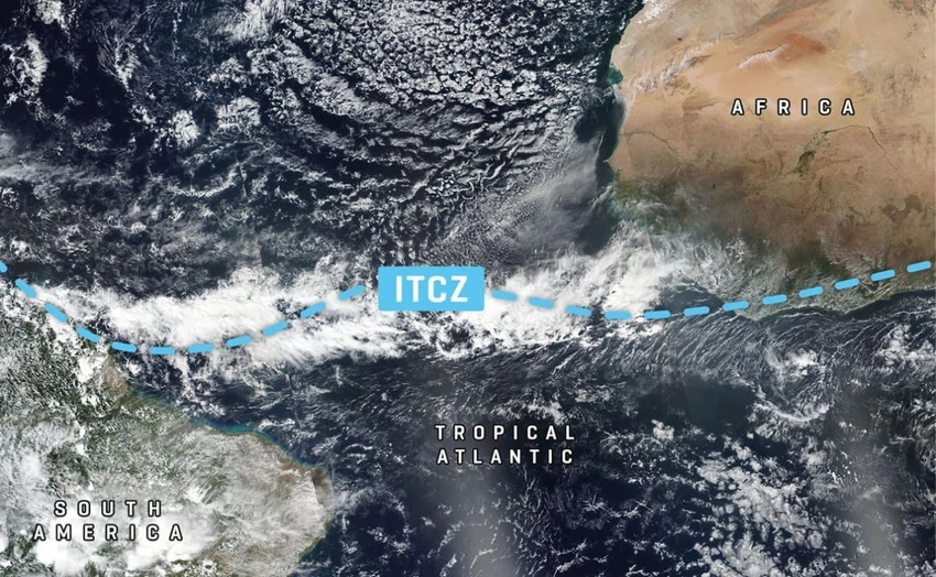
Weather forecasters at Arab Weather explain that the term tropical break refers to the tropical rain belt or the intertropical convergence zone (ITCZ), which is basically a belt of clouds and rain that is active around the entire equator, meaning that the trade winds from both hemispheres meet at this point, creating an upward movement of winds and the formation of rain clouds. As the image below shows, tropical winds from both hemispheres meet near the equator, creating an upward movement in the atmosphere, which produces clouds, storms and rainfall.
How the Intertropical Convergence Interval Affects Rainfall in Rare Regions of the Sahara Desert
Experts at "Arab Weather" explain that the intertropical convergence zone is very important because it affects the weather and rainfall in tropical regions, and can also affect the formation of tropical storms. Rainfall in the Sahara Desert depends on changes and transformations in the intertropical convergence zone, as the extension of the tropical break more towards the north in some seasons may bring with it rare rains deep into the Sahara Desert, as is happening currently and is expected to continue during the coming period.
Increased chances of rain in large parts of the Sahara Desert during the coming period
Global weather forecasts indicate that, over the next sixteen days, large amounts of rain will fall on areas in the Sahara Desert that are not accustomed to this compared to the annual average for those areas. Although these amounts may not seem high, if we look at the total annual amount, many areas may receive a few years’ worth of rain in a few days, as shown in the following map:
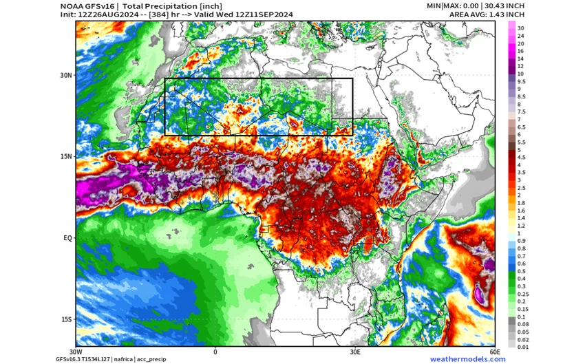
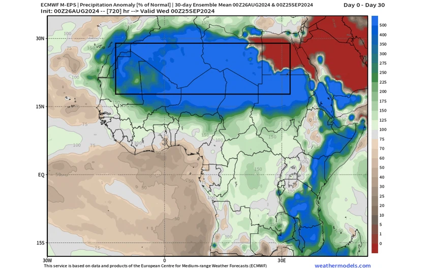
Considering the rainfall anomaly, the rainfall anomaly forecast indicates that a large part of the Sahara Desert will experience widespread rainfall anomalies over the next two weeks and possibly beyond, potentially reaching a maximum of 500% of the annual average and more than 1000% of the normal rainfall in the central regions.
Why is the current rainfall in the Sahara Desert a rare weather event?
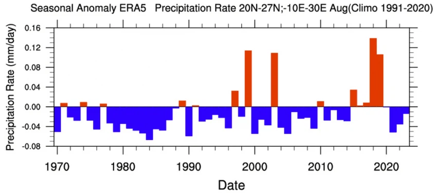
Weather experts at Arab Weather say that more than half of the Sahara Desert receives less than 25 mm of rainfall throughout the year, but as the tropical break moves further north, many areas there may receive more than 1000% of the annual average, and some of them will reach their maximum. The following graph of rainfall over the Sahara Desert for the month of August shows the anomaly of rainfall for the months of August over the past 53 years. We note that there are only 4 years that showed a strong anomaly, meaning that this has happened four times in the past five decades only.


Arabia Weather App
Download the app to receive weather notifications and more..