Climate report | After recording record numbers, Hurricane Beryl heralds a strong hurricane season in the Atlantic Ocean, and what is the relationship of the La Nina phenomenon to its development to the fifth degree (details)
")
Arabia Weather - After forming early and recording record numbers, Hurricane Beryl heralds an active hurricane season in the Atlantic Ocean, and Arabia Weather specialists reveal statistics about the strongest and rarest hurricanes in the Atlantic Ocean (Hurricane Beryl).
In detail: Hurricane Beryl first formed as a tropical depression on June 28, 2024, with wind speeds of 35 miles per hour. During the first 24 hours, the storm quickly intensified and turned into a hurricane with winds reaching 75 miles per hour. This was the maximum hurricane speed in the month of June within 24 hours. Hurricane Beryl quickly developed into an extremely dangerous Category 4 hurricane, thus becoming the first hurricane. A category 4 hurricane formed in June, as archival data indicate that the previous record was for Hurricane Dennis when it became a category 4 hurricane on July 8, 2005. The significant increase in the temperature of the waters of the Atlantic Ocean due to climate change is one of the most important reasons for the rapid development of tropical cyclones in the years. The latter, which is expected to increase globally in the coming years.
After developing rapidly, Hurricane Beryl made landfall on Kariakoo Island on July 1, 2024, as a powerful Category 4 hurricane, with winds of 150 miles per hour and gusts that posed a real danger to the southern Windward Islands as the hurricane moved toward the Caribbean Sea, where it strengthened. As he moves.
On July 2, 2024, Beryl became the first Category 5 hurricane recorded in the Atlantic Ocean and the second Category 5 hurricane to occur in July after Hurricane Emily in 2005. According to the National Hurricane Center, Beryl beat Hurricane Emily's record for maximum sustained winds, as Beryl became The strongest Atlantic hurricane on record in July, with winds of 165 mph as only Hurricane Emily reached maximum sustained winds of 160 mph.
What is the relationship between the La Niña phenomenon and the rapid development of Hurricane Beryl?
The department specialized in tracking hurricane movement at the Arab Weather Center said that in addition to the high temperature of ocean water, there is another factor that indicates a particularly active hurricane season in the Atlantic Ocean, which is the possible development of the La Niña phenomenon later this summer, as studies indicate. The La Niña phenomenon reduces trade winds across the Atlantic Ocean and leads to a reduction in wind shear (change in wind speed and direction with height). Because the La Niña phenomenon is still in its early stage of development, the main hurricane development zone (the area in the tropical Atlantic Ocean where most tropical cyclones form) was close to record warmth, meaning that there was enough fuel for Hurricane Beryl to form at this time of year. .
Several reports were issued by the weather monitoring center at the Arab Weather Center during the activity of Hurricane Beryl, and the most important observations received by the weather monitoring center about Hurricane Beryl were as follows:
- The maximum wind speed around the hurricane's eye wall reached: 266 km/h, which is strong winds with a record speed
- The lowest observed value of atmospheric pressure at the center of the eye of the hurricane is 935 millibars, which is a very low value.
- The maximum observed height of waves: 15 meters, which is the height of a multi-storey residential building
- The area of the eye of the hurricane and its geographical extent reached about 31 thousand square kilometers and 300 meters, which means that its area exceeded the area of 4 Arab countries (Qatar, Bahrain, Kuwait, and Lebanon) combined.

Why is the development of Hurricane Beryl rare at this time of year?
Specialists at the Arab Weather Center said that the development of Hurricane Beryl at this time of the year is a rare occurrence for a large hurricane (category 3 strength or higher), let alone its development into Category 5, as the hurricane season begins on the first of September. According to the National Hurricane Center, Hurricane Beryl's development early in the season was startling to forecasters.
“Beryl’s early development is remarkable,” Matthew Rosencrans, chief hurricane season forecaster at NOAA’s Climate Prediction Center, wrote via email. He explained that the geographic location where Beryl formed in the tropical Atlantic Ocean, just east of the Windward Islands, was exceptional as there are characteristics in that region, such as increased trade winds and wind shear, that normally can hinder the intensification of tropical waves.
Weather forecasters at the Arab Weather Center said that even from a climatic perspective, less than 5 hurricanes develop every 100 years in the region where Beryl forms in the months of June or July, whereas in a normal situation hurricanes develop in this region in the months of August and September.
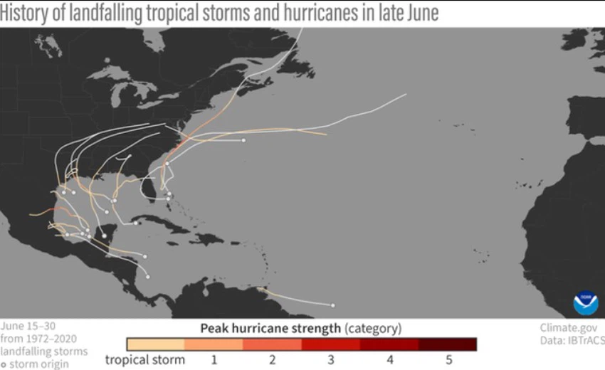
This map from the US NOAA shows the path of tropical storms that formed and made landfall in the Atlantic Ocean between June 15 and June 30 from 1972 to 2020, with no hurricanes having formed before during this period, proving that Hurricane Beryl is considered a rare occurrence. At a time like this.
The warming of the waters of the Atlantic Ocean played an important role in the development of Hurricane Beryl
Meteorologists at the Arab Weather Center say that at this time of the year, ocean temperatures are not warm enough, whether on the surface or in the depths, to fuel such powerful hurricanes, and that strong winds are still present across this region due to fronts. Cold and cold basins in the late season. But as we mentioned, ocean temperatures are record warm this year, and wind shear has been very low as well, creating ideal conditions for Hurricane Beryl to develop rapidly.
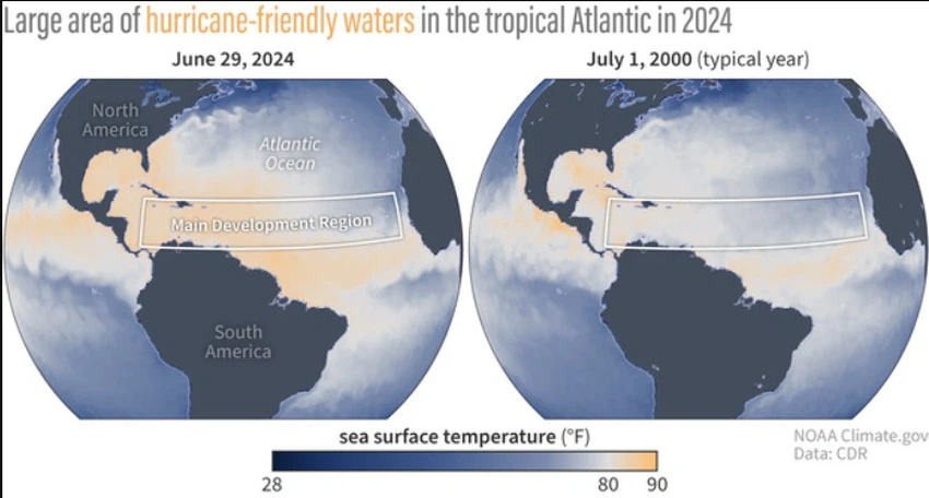
As a comparison, sea surface temperatures in the North Atlantic Ocean on June 29, 2024, compared to July 1, 2000. Areas in orange depict temperatures above 80 degrees Fahrenheit — the temperature needed to fuel hurricane development. Temperatures across the main area of tornado development at the end of June 2024 were broadly warmer than on July 1, 2000, when temperatures were closer to average.
Weather experts said that Beryl may be a bad omen for what comes next, with warm ocean temperatures and low wind shear, as these conditions have some scientists concerned about how the season will develop once the La Niña phenomenon fully kicks in later this summer and with the peak of the hurricane season approaching in Next September.
The path of Hurricane Pearl and the places it affected
Hurricane Beryl moved from Carriacou, the Cayman Islands, Jamaica and the Yucatán Peninsula before making landfall on the Texas coast as a weak Category 1 hurricane, but it caused catastrophic damage and broke more records, with more than two hundred hurricane warnings issued in one day. This is the largest number of tornado warnings ever issued on a single day in July. Beryl's influences included Texas, Louisiana, Arkansas, Mississippi, Kentucky, Indiana, Pennsylvania, and New York.


Arabia Weather App
Download the app to receive weather notifications and more..