Climate Report | La Niña Phenomenon Will Not Be as Strong as Expected, What Impact Will This Have on Global Weather Patterns, Including the Arab Region?
Arab Weather - The fall season begins from a meteorological perspective on the first of September, and continues for three months until the end of November. The beginning of the fall season this year coincides with the beginning of the development of a climate phenomenon in the tropical waters of the Pacific Ocean, which is the La Niña phenomenon.
Meteorologists are anxiously awaiting the outcome of the La Niña phenomenon in the Pacific Ocean, and the possible impacts that could accompany its development this fall and winter, whether in terms of rainfall or temperatures.
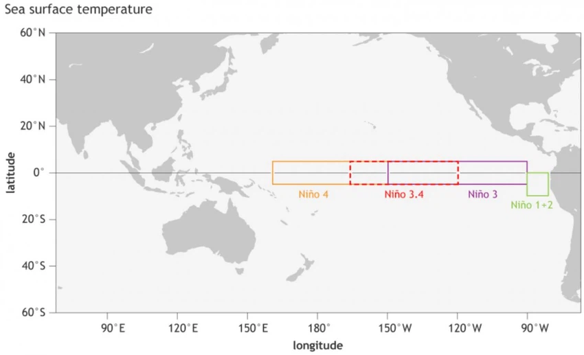
The experts at "Arab Weather" said that the La Niña phenomenon is the cold phase of the Pacific Ocean oscillation, which shifts between two cold and warm phases, where the cold phase is called La Niña, while the warm phase is called El Niño. The difference in the anomaly of ocean temperatures (warmer or colder) occurs in specific areas of the Pacific Ocean, as shown in the image below, and the main areas 3 and 4 together cover a large part of the tropical Pacific Ocean.
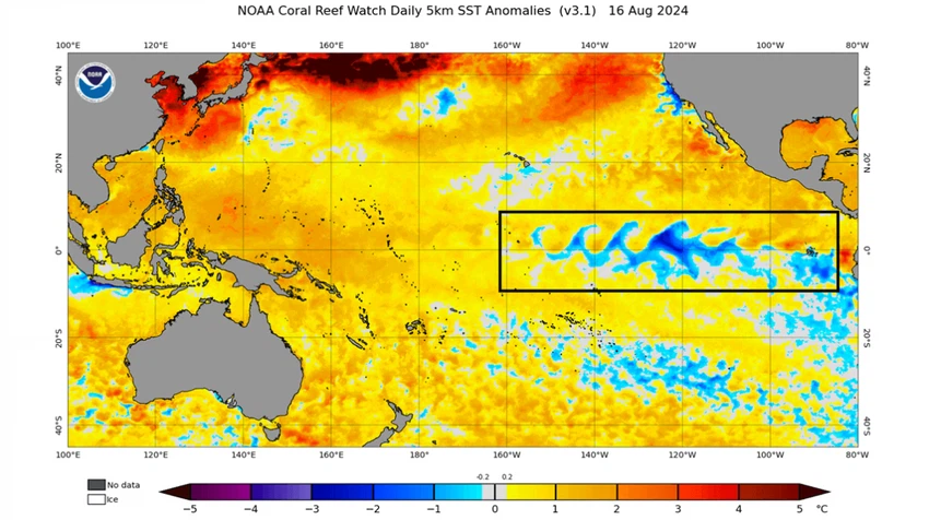
Looking at the latest analysis of ocean temperature anomalies, we can see a lower-than-normal temperature anomaly in the central and eastern regions of the tropical Pacific Ocean that is wave-like and caused by strong easterly trade winds pushing water westward, creating eddies on the ocean surface.
How does the change in the temperature of the tropical Pacific Ocean affect weather around the world?
Experts at Arab Weather said that statistical data indeed indicate that the La Nina phenomenon has a significant impact on tropical rainfall and atmospheric pressure patterns between the ocean and the atmosphere. The image below shows the expected atmospheric circulation pattern in light of expectations of the La Nina phenomenon growing in the fall and winter of this year.
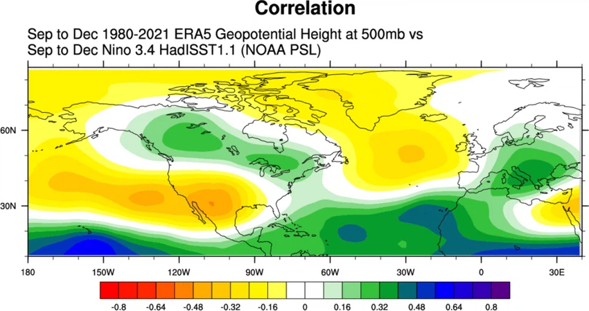
Forecasts indicate that a high pressure system will develop in the North Atlantic Ocean, extending as far north as Greenland and to the west of it, while a low pressure area will cover Canada and the northeastern United States, and a high pressure system will extend from the North Pacific Ocean to the southern United States.
Looking at temperature patterns, temperatures are expected to be below normal over Alaska and parts of Canada due to being under a low pressure area while the western United States is warmer, with a colder anomaly heading toward the far northeastern and northwestern parts of the country.
Rainfall rates and La Niña phenomenon
Experts at Arab Weather said that the rate of rainfall statistically varies from one season to another, coinciding with the presence of the La Niña phenomenon, as forecasts indicate the possibility that the central and southern regions of the United States will witness a drier pattern than usual, while wetter weather conditions appear in the northwest and northeast of the United States and Canada, and in Europe, it is expected to witness drier weather conditions in the west and higher than usual rainfall in the central and eastern parts.
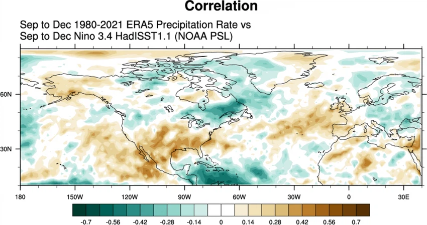
A broader look at temperature and precipitation patterns
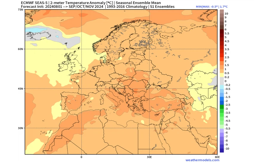
Looking to Europe, we can see above-normal surface temperatures across much of the continent. This suggests that a high pressure system is developing over the North Atlantic extending into Europe as shown by the ECMWF’s pressure behaviour forecast, and a low pressure area can be seen over the northwest, bringing milder air masses into the UK and Ireland.
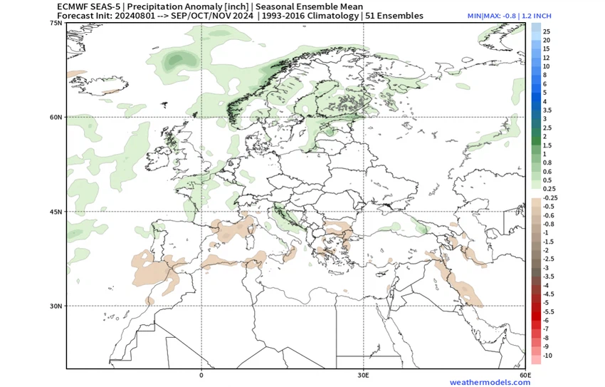
Rainfall forecasts point to a drier autumn across much of southern Europe, while an area of low pressure is expected to cover northern parts and over the UK and Ireland, potentially bringing more rain there as well as central parts.
What is the impact of the development of the La Niña phenomenon on Arab countries?
Weather forecasters at the Arab Weather Center say that the development of the La Nina phenomenon is statistically linked to a season of below-average rainfall in the Arab region, including the Levant. It is also linked to the development of the Siberian high and its extension at intervals towards the Arab regions, which brings colder and drier weather than usual. However, this cannot be completely confirmed without ignoring the effects of other weather patterns around the world on the climate of the Arab region, such as the warming of the seas and oceans, in addition to the behavior of the northern parameters (the North Pole and the North Atlantic parameters).
Arab Weather experts note that these forecasts are based on long-term probability maps with the statistical factor being included in the equation, so the forecasts remain variable due to the long time period, and we will provide you with the latest weather developments as soon as they are issued.
See also:
New Record: Mediterranean Sea Records Hottest Average in Decades
Arabia Weather App
Download the app to receive weather notifications and more..


