Emirates | An extension of relatively low air pressure as of Tuesday and chances of thunderstorms in some areas
Arab weather - weather maps indicate that the UAE is affected by an extension of a relatively low air pressure area, accompanied by a rush of quantities of moisture coming from southern Pakistan and the Arabian Sea towards the various layers of the atmosphere, especially the constructive ones (medium and high) starting from Monday and intensifying on Tuesday, so quantities of clouds appear At different heights, it is interspersed with cumulus clouds, especially with the afternoon and evening hours.
The opportunity is ripe for thunderstorms of varying intensity to rain on parts of the south and southeast of the country, specifically the city of Al Ain, in addition to parts of the eastern mountains, which may be accompanied by the activity of surface winds that raise dust and dust locally.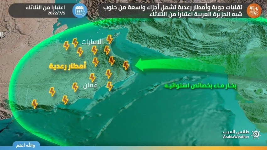
Chances of rain extend to separate areas on Wednesday and Thursday
Large amounts of moisture continue to flow through the various layers of the atmosphere on Wednesday and Thursday so that the weather remains cloudy, and the opportunity is ripe for local showers of varying intensity in narrow and scattered geographical ranges of the Emirates. Opportunities include some northern and western regions, specifically parts of Madinat Zayed, in addition to to the southernmost regions.
The rain is accompanied by the occurrence of lightning, thunder, and perhaps thunderstorms, in addition to the activity of descending winds from cumulus clouds, which raise dust and dust and lead to a decrease in the horizontal visibility within the thunderclouds effect.
Weather forecast for the next four days from the National Center
- Monday 04 July 2022
Clear to partly cloudy at times, and some clouds appear to the east in the afternoon, and humid at night and Tuesday morning over some coastal and inland areas, and southeasterly winds turning to northwesterly light to moderate speed, active at times to the east, causing dust, and their speed from 10 to 25 up to 35 km. / o, and the sea is light to medium waves in the Arabian Gulf and in the Sea of Oman.
- Tuesday 05 July 2022
Partly cloudy to cloudy at times, especially to the east, with the possibility of light rain, southeasterly winds turning to northwesterly light to moderate speed, active at times, exciting to dust and dust, and their speed is from 10 to 25 up to 40 km / h, and the sea is light in the Arabian Gulf and light To medium waves, turbulent late at night in the Sea of Oman.
- Wednesday 06 July 2022
Partly cloudy to cloudy at times with a chance of scattered rain, especially in the east, with a noticeable decrease in temperatures, southeast to northeasterly light to moderate winds, sometimes active and causing dust and dust, and their speed from 10 to 25 up to 40 km / h, and the sea Light to medium waves, turbulent sometimes with clouds in the Arabian Gulf and in the Sea of Oman.
- Thursday 07 July 2022
Partly cloudy to cloudy at times with a chance of scattered rain, especially to the east, and moderate southeast to northeasterly winds, sometimes active, especially with clouds that raise dust and dust, and their speed is from 15 to 30 up to 40 km / h, and the sea is moderate to turbulent at times with waves. Clouds in the Arabian Gulf and the Sea of Oman.
For more news, download the Arab Weather app from here
God knows.


Arabia Weather App
Download the app to receive weather notifications and more..