High activity in the polar vortex and snowstorms expected in the United States and northern Europe
Arab Weather - The latest analyses of weather maps from what is called computer simulation, which show the distribution of air masses in the Arctic region, indicate that there will be significant activity in the stratospheric polar vortex during these days and the coming days. Low atmospheric pressures are recorded over the Arctic, which means that the polar vortex is coherent and its activity is increasing during the coming period, which means that there are opportunities for several regions to be exposed to cold waves, especially America and North Asia.
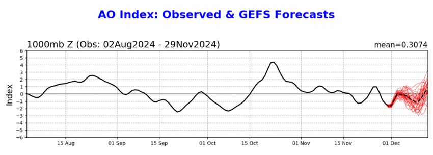
The Arctic Oscillation is heading towards a neutral or slightly positive pattern in the coming period.
The Arctic Oscillation Index indicates that the values are likely to move towards neutral or slightly positive phase, resulting in a decrease in atmospheric pressure over the Arctic vortex. This change may lead to the accumulation of cold air masses in the northern regions, indicating a significant shift in the weather system.
Experts at the Arab Weather Center pointed out that the Arctic Oscillation Coefficient is an indicator for monitoring changes in atmospheric pressure above the Arctic Circle, and that changes in this coefficient affect weather patterns in the Northern Hemisphere.
When the Arctic Oscillation coefficient is positive, pressure decreases in the Arctic and pressures increase in other regions, while when it is negative, pressures increase in the Arctic and decrease in the central regions.

Due to the activity of the polar vortex, huge polar air masses are rushing to North America, and the weather is very cold
As a result of the great activity in the polar vortex, very cold and large air masses rush directly from the North Pole towards the North American continent and Canada, causing very cold winter weather, as temperatures in some areas drop to about 40-45 degrees Celsius below zero, which means a severe wave of bitter cold, with widespread snowfall in several states, especially the northeastern states.
Polar Vortex Sends Cold Winds to More Areas of the Northern Hemisphere
The polar vortex also pushes very cold air masses towards northern Europe, bringing with it snowstorms accompanied by strong winds and heavy snowfall, which will accumulate and hinder aspects of public life, with temperatures dropping sharply below zero degrees Celsius. This is due to the increasing structure of the stratospheric polar vortex and its greater cohesion.
Meteorologists at the Arab Weather Center are monitoring the possibility of a very cold polar air mass rushing from northern Europe to its south, as a result of the expansion of the Azores high pressure system. If the weather systems remain stable, southern European countries, especially Spain, France and the surrounding countries, will be exposed to a strong cold wave accompanied by negative temperatures and heavy snowfall.
And God knows best.
Arabia Weather App
Download the app to receive weather notifications and more..


