important | A tropical humid wave crosses the region and improves rain chances next week in many areas of the Sultanate of Oman
Arab weather - Our indicators are increasing in the Arab weather that the Sultanate of Oman is affected by a rainy situation accompanied by precipitation of varying intensity in separate areas of the northern Sultanate of Oman next week. As for temperatures, the week is expected to witness clear thermal fluctuations in various regions, God willing.
A clear difference in temperatures during the week
It is expected that the intensity of the hot weather in the northern regions will gradually decrease during the first half of the week as a result of the blowing of humid sea currents that reduce the temperature, while the presence of the seasonal low temperature will continue from the west in the Empty Quarter, accompanied by the same hot air mass that will be located in that region.

As of Wednesday, the flaming center that accompanies the very hot air mass is moving towards the eastern regions of the Sultanate, which intensifies the incendiary atmosphere again in most of the interior regions of the Sultanate, so that temperatures are recorded in the mid-forties and approaching fifty degrees in some regions, especially the eastern states, and the regions will not be The coastal areas are far from the hot weather, where it is expected to live in a gloomy atmosphere, so that the temperatures are in the late thirties, in addition to the relatively high humidity compared to the interior regions, which leads to a relative increase in the feeling of heat.
The rain is back again
The weather forecast staff in the Arab weather monitors a high probability of tropical moisture flowing from the Arabian Sea towards the Sultanate of Oman, which creates unstable weather conditions as of Monday, as cumulus thunderclouds multiply and rains fall with varying intensity, as a result of the increasing effect of the surface depression, which contributes to the emission of Rising currents enhance the process of building rain clouds.
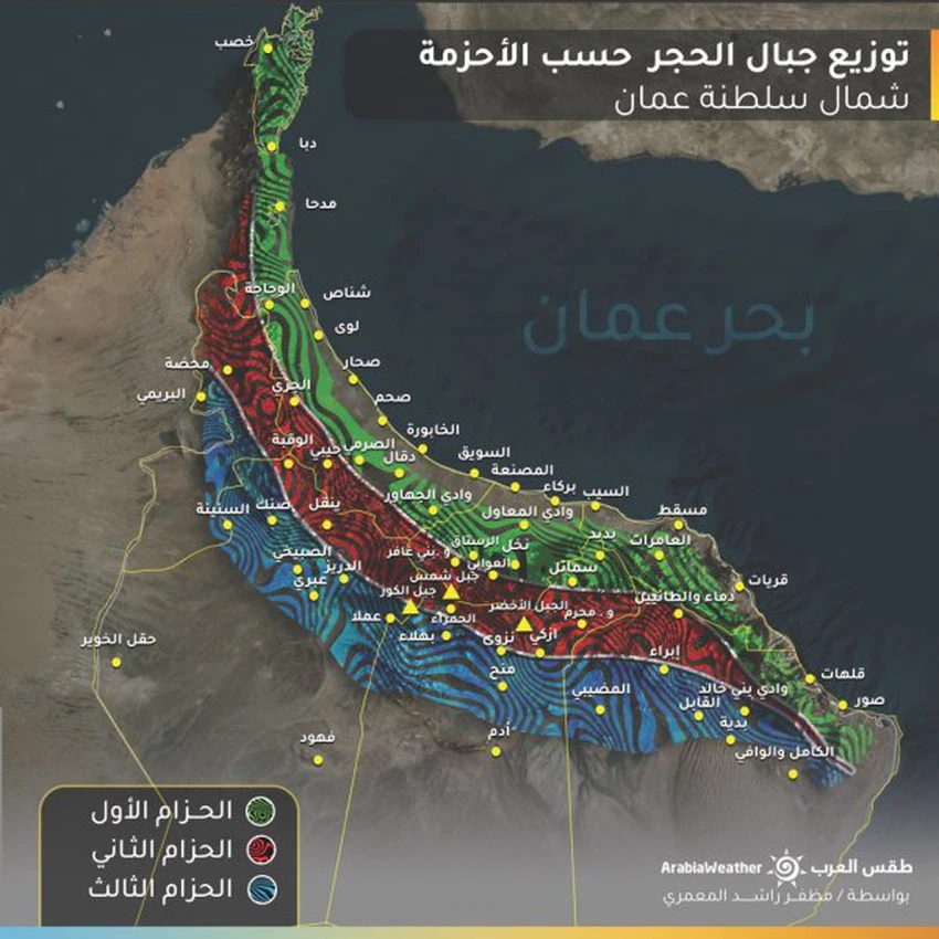
As of Monday, the unstable weather is expected to start affecting the Al Hajar mountain range, and the autumn rains will continue in parts of the Dhofar Governorate and the city of Salalah, where convective thunderstorms and rain will multiply with varying intensity, and will gradually expand on Tuesday to include the areas surrounding the Hajar Mountains and parts of the region. It is expected that the intensity of rain will focus on the second and third belts, and be accompanied by rainfall of varying intensity, thunderstorms and perhaps hail showers, in addition to the activity of downward winds that raise dust and dust.

The distribution of the Al-Hajar Mountains known as (Al-Ahzam) designed by our colleague Muzaffar Rashid
It is expected that these rains will cause a large flow of valleys and reefs, and may form torrents that may be torrential at times in several areas. This expected weather activity comes after a short interruption, and the performance of the rainy season is much less than was assumed until this period.
Arabia Weather App
Download the app to receive weather notifications and more..


