Important Details of the rain forecast and the areas covered for Thursday
Arab weather - Sinan Khalaf - Large areas of the Kingdom of Saudi Arabia are affected, starting today, Thursday, with the start of a new rainy state, where rain thunderstorms are expected to intensify and rain will fall heavily, God willing, on the western and southwestern highlands of the Kingdom. The rain will expand on Saturday. To cover large areas of the Kingdom, from Tabuk in the far north to Jizan in the far south!
The prevailing air system in the region
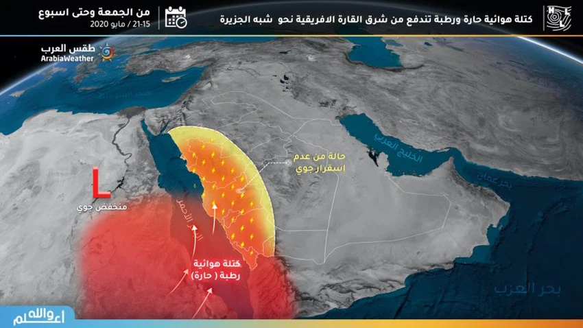
As for the reasons for these weather fluctuations, they are caused, according to the cadre of predictions, from the positioning of an air depression over Egyptian lands. This depletion will be pushed by a hot and humid air mass towards the Red Sea region, western Saudi Arabia, eastern Egypt and Sudan. The western highlands of the kingdom and some internal parts.

Regions covered by rain forecast on Thursday
As for the areas covered by the forecasts of thunderstorms and rain, they begin on Thursday in the western and southwestern highlands of the Kingdom, such as the beginning of the Tabuk and Madinah highlands, and parts of the regions of Makkah and Taif and an extension to the highlands of Al-Baha, Asir, Jizan and Najran.
Some thunderstorm clouds may form on the western parts of Hail and Qassim regions, and possibly the western parts of the Riyadh region, away from the capital.
The highlight of this rainy state
Perhaps the most prominent characteristic of this rainy state is the strength of sandstorms caused by the falling winds that accompany thunderstorms. This rainy state comes in conjunction with the rise in temperatures to 40 degrees Celsius in many areas, which means that the soil dries up in a way that loses its cohesion and makes it easy to fly with the wind , Which increases the likelihood of sandstorms forming.
This weather condition warns of:
1- The intensity of thunderstorms that accompany rain clouds
2- The intensity and intensity of rain in narrow ranges, which may work to form torrents in some areas
3- The intensity of the falling winds and the dust waves caused by thunderstorms
Arabia Weather App
Download the app to receive weather notifications and more..


