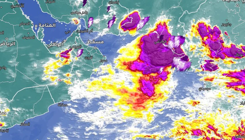
Important | Giant thunderclouds east of the Arabian Sea and Arabian Weather explains its forecasts for their possible development or impact on Oman and the region
Sinan Khalaf - The attention of weather enthusiasts and fisheries experts is directed towards the Arabian Sea, specifically the eastern part of it, between India and Pakistan, where artificial satellites monitor the activity of giant cumulus thunderclouds laden with heavy rain between the state of Gujarat and the city of Karachi.
Giant thunderclouds east of the Arabian Sea
A huge mass of rainy thunderclouds monitored by satellites
In the details, satellite images are currently monitoring a tropical disturbance currently centered along the coasts of western India and Pakistan, where a large mass of cumulonimbus thunderclouds appears, directly affecting the coastal parts with heavy rains and floods, with expectations that the impact of this weather system and the accompanying thunderclouds will continue. Rain in the area until Friday.

An important link to follow tropical disturbances in the Arabian Sea via satellite from here
No direct effects on Oman and Yemen
Arabia Weather rules out the development of the tropical disturbance into a tropical storm or hurricane
Regarding the possibility of the tropical disturbance developing into a tropical storm or hurricane, the forecast team at the Regional Arabia Weather Center confirmed that the current tropical disturbance centered to the east of the Arabian Sea will wage war with many deadly factors that limit its energy and prevent its movement towards the east, most notably the strong monsoon winds that It will repel and destroy clouds and prevent them from growing vertically, and God knows best.
Arabia Weather App
Download the app to receive weather notifications and more..


