important | Saudi regions covered by rain forecasts during the next 48

Arab weather - Sinan Khalaf - It began at noon today, Wednesday, that separate parts of the Kingdom of Saudi Arabia were affected by a "weak to medium" weather condition, which is considered the first of its kind and the most comprehensive since the beginning of this month of April. Dust waves caused by downward winds in thunderclouds formation areas.
A new rainy situation begins to affect the Kingdom today
The areas covered by the rain forecast for the next 48 hours
As for Wednesday, it is expected, God willing, that the chances of rain will focus on the western and southwestern sectors of the Kingdom, and by that we mean separate parts of the Makkah region, separate parts of Al Baha, Asir and perhaps parts of Jazan, as convective clouds are expected to form locally in these areas. As a result, showers of thunderstorms, and the western parts of the Riyadh region are affected by the activity of thunderstorms in the evening hours, accompanied by localized rain showers, and the activity of downward winds that raise dust and dust, with a weak chance for the remnants of clouds to reach the city of Riyadh in the late hours of Wednesday night. Thursday dawn.
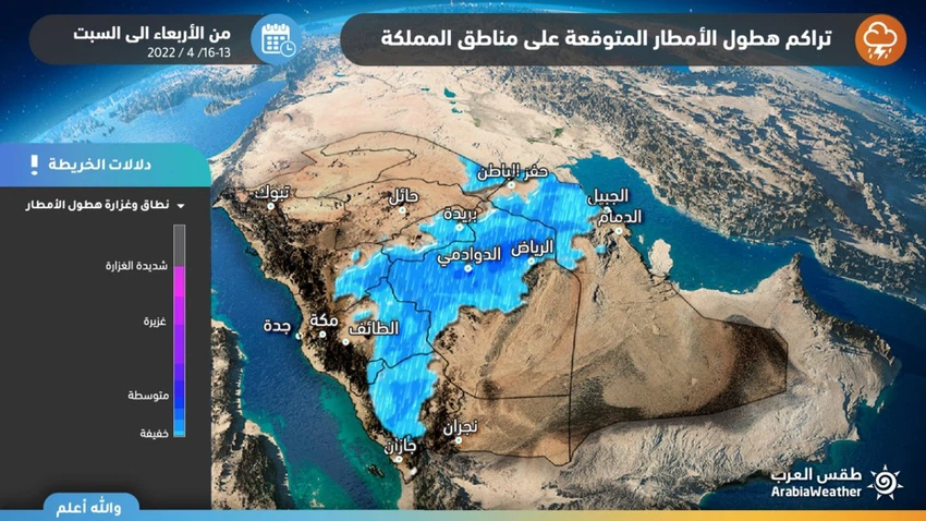
As for Thursday, the Riyadh region, including the capital, is more affected by weather fluctuations, so that large amounts of cumulus clouds form in the sky of the western sector of the Riyadh region, especially with the evening hours, and later extend towards its north, and, God willing, scattered showers of rain, accompanied by thunder, fall before With downward winds causing dust and dust in many areas, the remnants of these clouds may extend to affect limited parts of the eastern region.
To read the best, download the Arabia Weather app from here
The science behind this air turbulence
This state of atmospheric turbulence comes as a result of the concentration of a shallow air depression in the atmosphere of central Saudi Arabia, in addition to the convergence of hot air in the Arabian Peninsula with colder air coming from the north, and the presence with activity of the Sudan depression, which leads to the emergence of air turbulence and the emergence of a state of atmospheric instability that is formed As a result, strong clouds accompanied by thunderstorms.
See also:
Riyadh | After the drought.. Successive omens with several chances of rain in the coming days


Arabia Weather App
Download the app to receive weather notifications and more..