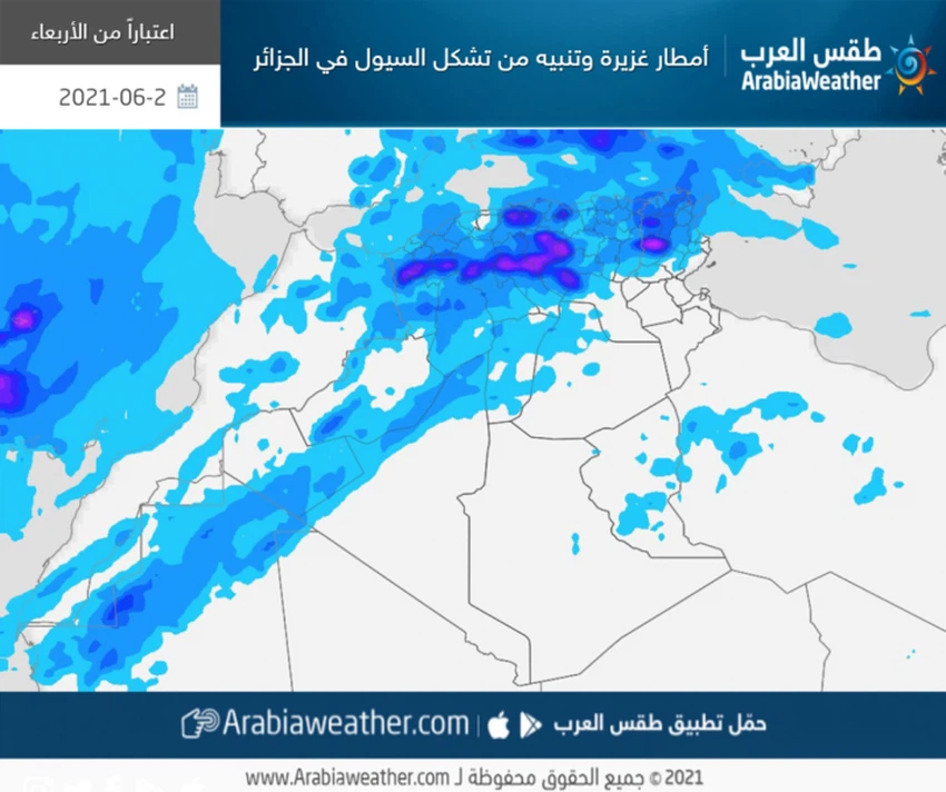
important | Warning of a wave of rain that brings torrential rain in the interior of Algeria
Arab weather - Thunderstorms began to fall in a number of areas today, Wednesday, as clouds gradually multiplied at different heights to create the opportunity for showers of thunderstorms in separate areas of Algeria.
Advanced warning of the danger of floods
According to the weather forecast department specialized in meteorological conditions, the Republic of Algeria will be under rain on a daily basis, with intensification in the intensity and intensity of thunder clouds during the evening and night hours, so that thunderclouds and strong thunderstorms are blowing, accompanied by active wind movement and precipitation between medium and heavy, in addition to precipitation papyri.
As of Wednesday evening hours and during the coming days, weather fluctuations will intensify in most of the interior regions, and the rains will become heavy to very heavy, as the intensity of rain is expected to rise in some of the northern heights, so that medium to heavy showers of rain fall in the highlands of Setif, Batna, Djelfa , Tlemcen and parts of Constantine, in addition to the areas surrounding these areas, with a warning of the danger of torrential rains in some areas, God willing.

Rising temperatures in the eastern states الولايات
As for temperatures, there will be a gradual rise in temperatures in the coming days in the eastern regions, while it will decrease in the western parts. The weather will be relatively hot in the northern regions in general, and moderate in the coastal areas, and hot to very hot in the rest of the regions, especially the southern and eastern states. Also, southerly moderate winds blow, sometimes active and causing dust and dust, in large parts of Algeria, especially desert areas.
During the night hours, a warm atmosphere prevails in most of the central and southern regions, while it may tend to be cool in the late night hours in the northern regions, including the coastal ones. The surface humidity levels also rise and light fog forms on the northern parts that may extend to some coastal areas.
This air activity comes as a result of the deepening of a desert depression in the Algerian desert, which contributes to the rush of large amounts of moisture in those effective layers of the atmosphere that extend from (1.5 km to 5 km above the surface of the earth), and this leads to an active and effective response to the desert depression, accompanied by the proliferation of clouds. Cumulus rain on several parts of the republic, God willing.
Important recommendations to be taken seriously
- It is advised to pay attention to the risks of sudden torrential rains when thunderstorms, especially in valleys and cliffs, where it is advised to stay away from valleys, reefs and torrents.
- Attention to the high proportion of dust in the atmosphere.
- Pay attention to the danger of lightning and severe thunderstorms by taking shelter inside buildings.
- Stabilize the outdoor collectibles for fear of strong winds during the passage and formation of thunderclouds. . . . . . . . . . . . . . . . . . . . . . . . . . . . . . . . . . . . . . . . . . . . . . . . . . . . . . . . . . .
Arabia Weather App
Download the app to receive weather notifications and more..


