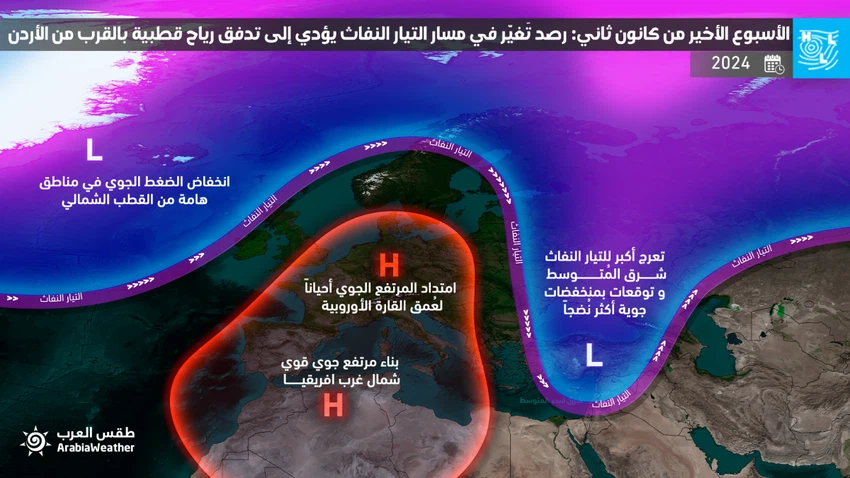
Jordan | A change in the path of the jet stream was observed, leading to the flow of polar winds near the region in the last week of January:
Arabia Weather - The remote sensing systems at the “Arab Regional Weather Center” are monitoring a radical change in the shape and path of the jet stream in the Northern Hemisphere, starting in the last week of January 2024, and the specialists at the “Arab Weather Center” are closely following it. The consequences of this major change in the jet stream have been carried out through computer simulations and statistical calculations, which now indicate an increased chance of extremely cold polar winds flowing near Jordan and in the Levant region, which will cause temperatures to drop to very low levels throughout the Middle East. Fears of cold waves affecting the region.
On a related level, this change is seen as potentially being positive as it is an indication that weather patterns will be distributed in a new way in a large part of the Northern Hemisphere, in a way that will seem to lead to the return of usual winter behavior to the region through increased chances of the formation of mature winter weather depressions in The region, where Jordan and the eastern region of the Mediterranean have been affected since the beginning of the rainy season by many weather depressions, which brought excellent amounts of rain, thank God, exceeding their usual performance to date 1/16/2024 in the majority of the Kingdom’s governorates. However, these depressions, despite Its frequency and lack of interruption for long periods in the area were not deep enough to be classified as advanced grades, and it was not winter-ripe.

Extremely cold waves over the region are looming
Despite the long period of time, which leads to great confusion in the work of computer simulation systems of the consequences of these changes to the jet stream on the region, it can be said that the chances of the region being affected by cold waves, a significant drop in temperatures, and the occurrence of frost waves have become moderate to high in recent days. Starting this month in the Middle East, including Jordan, Palestine, Syria, Lebanon, and Iraq, in addition to the Kingdom of Saudi Arabia and the Gulf states.
Some computer simulation systems indicate that temperatures may be lower than normal in some areas by the end of the month by at least 5 degrees Celsius.
Does this mean snow falling?
The arrival and flow of polar winds near the region and Jordan would impose on the Levant region a significant drop in temperatures and the occurrence of large-scale frost waves if they occur, while in snow it requires more complex weather systems to cause widespread precipitation and snow conditions. Which cannot be sensed from now due to the long period of time, but with this form of weather patterns and the jet stream, and through statistical calculations of similar patterns in previous years, it can be said that the chance of snowfall rises theoretically with such similar conditions.
As a summary, the chance of snow events occurring with such weather patterns increases, but it is not possible to determine their occurrence and comprehensiveness from now due to the large changes that can occur due to the long period of time.
Gaza is calling for help before these cold waves occur
With the increase in these signs of the occurrence of cold waves and depressions in the region, this matter cannot be viewed in isolation from what is happening in the Gaza Strip, as it is feared that these cold waves and weather conditions will further complicate the scene for Gazans as a result of what the occupation forces are doing. From military operations there.
The scientific reason behind all these changes
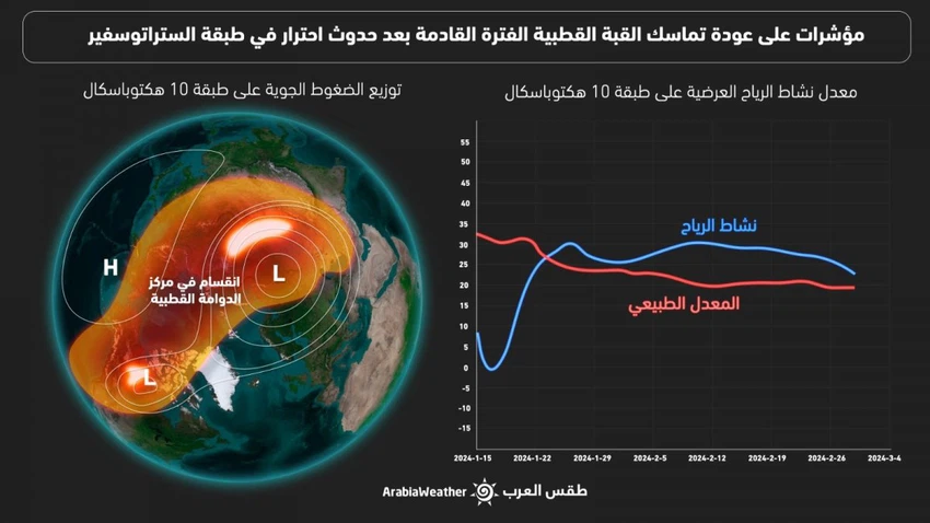
The recovery of the polar dome and the return of deep air depressions to important areas of the Arctic Circle during this period are among the most important reasons behind these radical changes in the shape of weather patterns, as in a normal situation the so-called polar vortex is cohesive during the winter and a westerly air current revolves around it. High-speed in a cyclonic-like area of low atmospheric pressure, the polar jet stream is then activated, which helps direct weather systems. However, since the beginning of the current winter season, the polar vortex has witnessed a clear imbalance represented by a weakness and slowdown in the westerly winds, and this slowdown has reached its peak in These days, which has enhanced the growth of high atmospheric pressures in important areas of the Arctic and in all layers of the atmosphere, and this was sufficient to cause a shift in the center of the polar vortex, which was also reflected in computer simulation models that have become distorted and extremely low in accuracy. Usually, the talk here is more about models for long-term forecasts.
However, computer simulation systems have begun to sense a significant recovery of the polar vortex system in important parts of the Arctic Circle during the coming period, God willing.

God knows.
Arabia Weather App
Download the app to receive weather notifications and more..


