Jordan | A huge and very cold air mass of polar origins will remain near the Kingdom for several days, starting from Thursday 03-10-2022
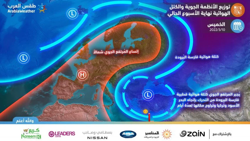
Arab Weather - Forecasters at the Arab Regional Weather Center say that the movement of a very cold polar air mass has been monitored, occupying large parts of the eastern European continent, and it is expected to continue its movement during the next few days towards the Black Sea and Turkey, and its place in those areas varies for several days. The air mass of Siberian origin occupies a huge million area and is considered one of the coldest types of air masses on Earth.
Forecasters add that the approach of this air mass to the region by the end of this week will dramatically drop temperatures compared to the past days and become much lower than their usual rates, and this mass is accompanied by a radical shift in weather in all regions of the eastern Mediterranean countries, including That kingdom.

Unlike previous reports, this report focuses on scientific analysis, explanation of aerial maps, and clarification of the most prominent characteristics of the polar mass.
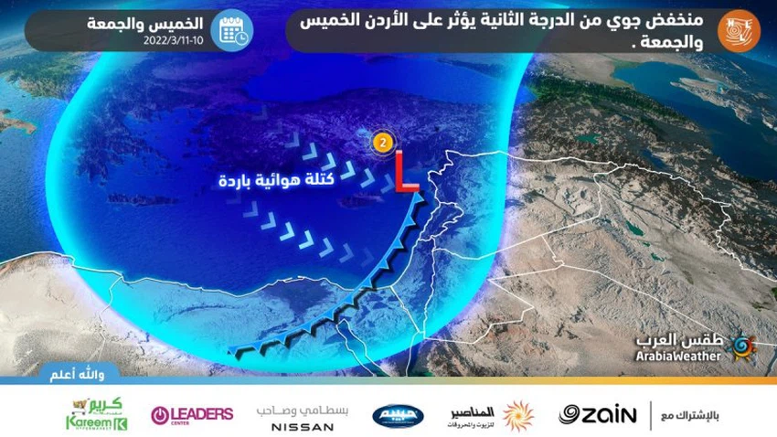
second degree depression
In the details, it is expected that the air mass will deepen over large parts of western and central Europe and expand in the north to reach the Scandinavian countries, and this coincides with the rush of a polar and very cold air mass that pushes the air mass to fall to eastern and southeastern Europe and the Balkan Basin, on Thursday 03-10- 2022. As a result, an air depression is formed in the eastern region of the Mediterranean Sea, affecting Jordan on Friday as a depression classified as a second degree according to the indicator measuring the intensity of air depressions, and it can be developed, God willing, as it is monitored inside the corridors of the Arab Weather Center around the clock.
According to the latest indicators received by the weather forecast team in the "Arab Weather", it is expected that the weather will turn on Friday 11-03-2022 to become cold in most areas, and very cold in the high mountainous heights, and often cloudy and rainy, God willing, in the north and center of the Kingdom, and it is associated with precipitation. Showers of hail at intervals, with indicators indicating the possibility of showers of snow at intervals over the high mountain heights that are more than 1100 meters above sea level.
Read more about the details of the air depression:

The strongest snow storm in 35 years in Turkey
According to weather experts at the Turkish Meteorological Authority, the results of the analysis of the archival maps show that the expected snow storm is the strongest in 35 years during the month of March and is expected to affect large parts of Turkey, as it is considered strong and unusual for this time of the year. , as a result of a direct rush of the very cold and polar air mass coming from Siberia through the Black Sea and then heading to Turkey, and staying in those areas for several days, varying in place. Where it is expected that large sectors of Turkey will witness great snowfall, even to the coastal areas and also to Istanbul, which is expected to witness significant snow accumulations.
Perhaps the most prominent question is, what prevents snow from falling this weekend, despite the arrival of cold air and of polar origin towards the Mediterranean?
A high air rush towards large parts of western and central Europe is the most important condition for a very cold air mass to rush towards the eastern parts of Europe, and it does not always mean that the mass descends in strength towards the eastern Mediterranean, as this requires the fulfillment of many other conditions. Where, according to the latest updates of the numerical models developed in the Arab Weather Center , the cold polar winds will be concentrated over the Turkish lands and the Balkan basin, part of which will flow behind the depression to Jordan, and therefore the polar cold will not be enough to cause a “snow” in the capital or the Kingdom, but it may be sufficient. For some snowfall over high mountains if these polar winds coincide with precipitation.
As the arrival of this polar air mass in that region requires more complex weather systems to cause snowfalls, and despite the huge drop in temperatures expected on Friday, March 11, 2022, a large part of the Levant (Jordan and Palestine) is located on the edge of the polar mass, The reason for this, God willing, is due to the deepening of a winter storm in the southeast of the European continent and the largeness of the cold mass, which leads to the circulation of air attracted towards the center of that mass, preventing it from liberating and pushing it strongly towards the south, that is, the eastern Mediterranean.

It is expected that the aftershocks of this depression will be clearly present in the Kingdom next week, as with the accumulation of very cold polar air near the region, this imposes on the Levant region, including the Kingdom, the continuation of the significant drop in surface temperatures to nearly zero degrees Celsius in many The main cities of Jordan, with the chances of precipitation significantly reduced. According to the latest data, it is not excluded that frost will form in several parts of the kingdom. "Arab Weather" will follow up on the latest data and developments regarding the weather situation next week, in turn.
God knows
Arabia Weather App
Download the app to receive weather notifications and more..


