Jordan | A relatively cold air mass that affects the Kingdom gradually, with the middle of this week, requires warmer clothes
Arab Weather - The latest readings of the weather maps indicate that the eastern winds that have been affected by the Kingdom since Friday will end on Sunday, as temperatures will drop and return to their usual rates to slightly less, but the same maps indicate that there is a relatively cold air mass that is expected to rush towards the eastern Mediterranean And the Levant on Monday, coming from eastern Europe, will bring a noticeable drop in temperatures, and perhaps showers of rain in some areas.
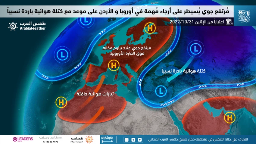
Regarding the details, the specialists at the Arab Weather Center said that a strong air rise dominates the regions of northwest Africa, reaching large parts of the European continent, where the latter is experiencing hotter and drier conditions than usual, and as a result a relatively cold air mass moves around this height and towards In the coming days, it will move directly towards the eastern basin of the Mediterranean, God willing, where the eastern European regions are considered the main feeder, God willing, for the Levant region and the entire eastern Mediterranean with cold air masses.

In a related context, it is expected that temperatures will tend to decrease on Sunday, becoming slightly lower than their usual rates for this time of the year, and the weather will be pleasant autumn in most areas, God willing, and the winds will be southeasterly, turning in the afternoon to northwest in most areas, except for the Badia. Eastern, where the speed is active in those areas and includes (the Jordanian/Iraqi border areas) and raises dust and dust in a way that may be thick sometimes in the mentioned areas. With the hours of Sunday/Monday night, temperatures decrease compared to previous nights, and a relatively cold atmosphere prevails in most areas, with a clear expected rise in surface humidity, to increase the chances of light fog and fog forming south of the capital, Amman, and it includes Queen Alia Airport in addition to some southern heights.
According to forecasters in the "Arab Weather", it is expected that temperatures will continue to decrease during the sea of the week, becoming several degrees lower than their usual rates, and the weather will be volatile between clear and partly cloudy and pleasant in most regions of the Kingdom during the day and even tends to be cold in the high mountainous heights. With the possibility of scattered showers of rain, concentrated in the north of the Kingdom. As for at night, the weather turns relatively cold, and the lowest in Amman and Jordanian cities is between 10-13 degrees Celsius, and less than that in the southern peaks, and such atmospheres are not suitable for outdoor sessions, especially in mountainous regions and cities, due to the relative cold in the atmosphere.
God knows.
Arabia Weather App
Download the app to receive weather notifications and more..


