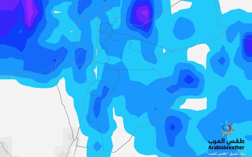
Jordan | A strong state of air instability begins at dawn on Saturday and calls for extreme caution from sudden torrents
Arab Weather - Increases in the late night hours. The Kingdom is affected by a state of atmospheric instability resulting from the convergence of an extension of a surface depression from the Kingdom of Saudi Arabia called the Red Sea Depression and a cold air mass in the upper atmosphere, in addition to this convergence coinciding with an outflow of moisture in the layers of the atmosphere The different areas, so that the opportunity is created with the late night hours and Saturday dawn for thunderstorms of rain, God willing, in separate areas that may be abundant in some neighborhoods and are associated with hail, which may cause the occurrence of what is called sudden torrents, especially in low-lying areas, slopes, valleys, and Reefs. The weather on Friday / Saturday night is generally cold and fluctuates between partly cloudy and mostly cloudy. The winds are from easterly to southeasterly, moderate in speed, active at intervals and significantly increase the feeling of cold.
As for Saturday, the Kingdom is affected by a situation that is equated to strong atmospheric instability, with the deepening of the cold air in the layers of the atmosphere and its convergence with the extension of the Red Sea depression so that the opportunity is ready for thunderstorms of rain, God willing, in separate areas of the Kingdom. These precipitation may be abundant in some neighborhoods and geographical areas and are associated with hail falls, which may cause the formation of so-called flash torrents in low-lying areas, slopes, valleys and reefs, and this includes several areas of the Badia.
The temperatures remain slightly lower than their average for this time of the year on Saturday, and the weather is relatively cold and fluctuating between partly cloudy and cloudy at times, and the winds are moderate to eastern, brisk at times.
With the hours of the night (Saturday / Sunday night), the state of atmospheric instability gradually decreases, with the opportunity remaining in the early hours of the night for more thunderstorms from rain, but especially in the eastern regions of the Kingdom in particular.
Surface humidity is high, and fog is formed in the eastern desert and some areas of the plains also with the late evening hours.
Important cautions regarding this state of atmospheric instability
The Kingdom's vulnerability to this situation, which is believed to be strong in terms of the instability of weather and weather, as many data indicate a high chance of the occurrence of so-called flash floods during this situation. This condition is also associated with thick cumulus thunderstorms, which means that there is a high chance of the occurrence of the so-called strong downward winds that lead to temporary sandstorms, in addition to lightning and lightning strikes.
Based on the above, there are a number of important recommendations that must be taken seriously regarding weather conditions during the next 24 hours, including:
- The need to be aware of the risks of sudden flash floods forming in valleys, reefs, low-lying areas, and common water gathering areas.
- The necessity of attention One of the same dangers is to stay away from the valleys, especially in the desert / Badia areas, and this includes the residents of the poetry houses.
- The external holdings are stabilized due to the danger of the strong downward winds that come temporarily.
- Attention is drawn from the low horizontal visibility due to the possibility of dust accompanying thunderclouds.
- Not to use electronic devices outside when there are thunderstorm clouds, and to take cover inside buildings when lightning strikes
God knows.
Arabia Weather App
Download the app to receive weather notifications and more..


