Jordan | Arabia Weather issues weather forecasts during Ramadan and a first overview of the days of Eid
Arab Weather - The weather forecast team recently issued weather forecasts for the month of Ramadan and the Eid al-Fitr period, which indicate clear fluctuations in temperature and the region being affected by Khamsin weather conditions at periods that may include chances of rain, God willing. Below are the details:
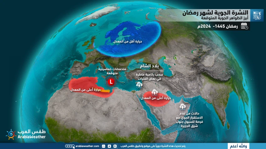
General situation
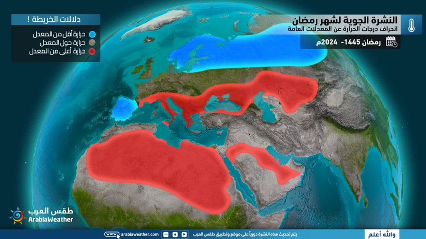
- Temperatures higher than the general average in various periods
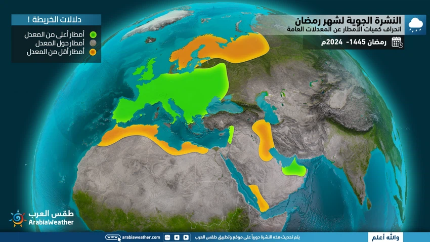
- A chance of rain on more than one occasion, God willing
- Monitoring the region’s impact on several weather conditions
- The concentration of dust in the atmosphere increases sometimes between the second and third week of Ramadan.
Aerial maps
The most important expected weather phenomena

Temperature deviation from general averages

Rainfall deviation from general averages

The first week (1-7 Ramadan 1445 AH), corresponding to 11-17 March 2024
Rainfall: below average
Temperature: higher than average
Description of the week:
- It is expected that the depressions will be active in the southwest of the European continent, extending to the countries of the Maghreb and the center of the European continent, leading to an increase in air pressure in the eastern basin of the Mediterranean Sea, the Levant, and Turkey.
- At the end of the period, temperatures drop and the opportunity for rain showers opens in several areas.
The second week (8-14 Ramadan 1445 AH), corresponding to 18-24 March 2024
Rainfall: above average
Temperature: above average
Description of the week
- At the beginning of the period, chances of rain remain possible, God willing, but soon the air pressure is expected to rise over parts of the southern and western European continent and the western basin of the Mediterranean Sea, which will lead to the movement of air activity and air depressions towards the eastern European continent as an extension of the eastern Mediterranean Sea.
- Khamsin weather conditions prevail at the beginning of the period, so this period will be characterized by clear temperature fluctuations and may be interspersed with some scattered rain, God willing. It is expected that the chances of relatively cold air masses extending during the first half of the period (8-11 Ramadan / 18-21 March) will improve and rise. Temperatures then quickly became higher than average for the entire period.
The third week (15-21 Ramadan 1445 AH), corresponding to 25-31 March 2024
Rainfall: about average
Temperature: higher than average
Description of the week
- Once again, atmospheric pressure is expected to rise gradually over the Levant, Turkey, and the eastern basin of the Mediterranean Sea, due to remarkable activity of air depressions over the British Isles and all areas located from the Scandinavian countries all the way to Spain.
- Khamaseen weather conditions prevail in some periods, so this period will be characterized by clear temperature fluctuations and may be interspersed with some scattered rain, God willing.
The fourth week and the rest of the month (22-30 Ramadan 1445 AH), corresponding to 1-9 April 2024
Rainfall: about average
Temperature: above average
Description of the week
- Similar weather systems are expected to prevail for the third week in various regions.
- Temperatures remain higher than normal throughout the period, with humid westerly currents and scattered rains continuing from time to time.
Eid al-Fitr weather, April 9-12, 2024
Rainfall: below average
Temperature: above average
Description of the period
- It is expected that the high altitude will continue to dominate the Levant.
- The weather will be moderate, with temperatures close to average to slightly higher, and chances of rain are present in limited areas, especially towards the end of the period.
- God knows
Note: It is strictly prohibited to transfer this information, data and weather forecast, publish it on social media and others, and/or dispose of it in any way without obtaining prior written approval from ArabiaWeather, under penalty of legal accountability .
Arabia Weather App
Download the app to receive weather notifications and more..


